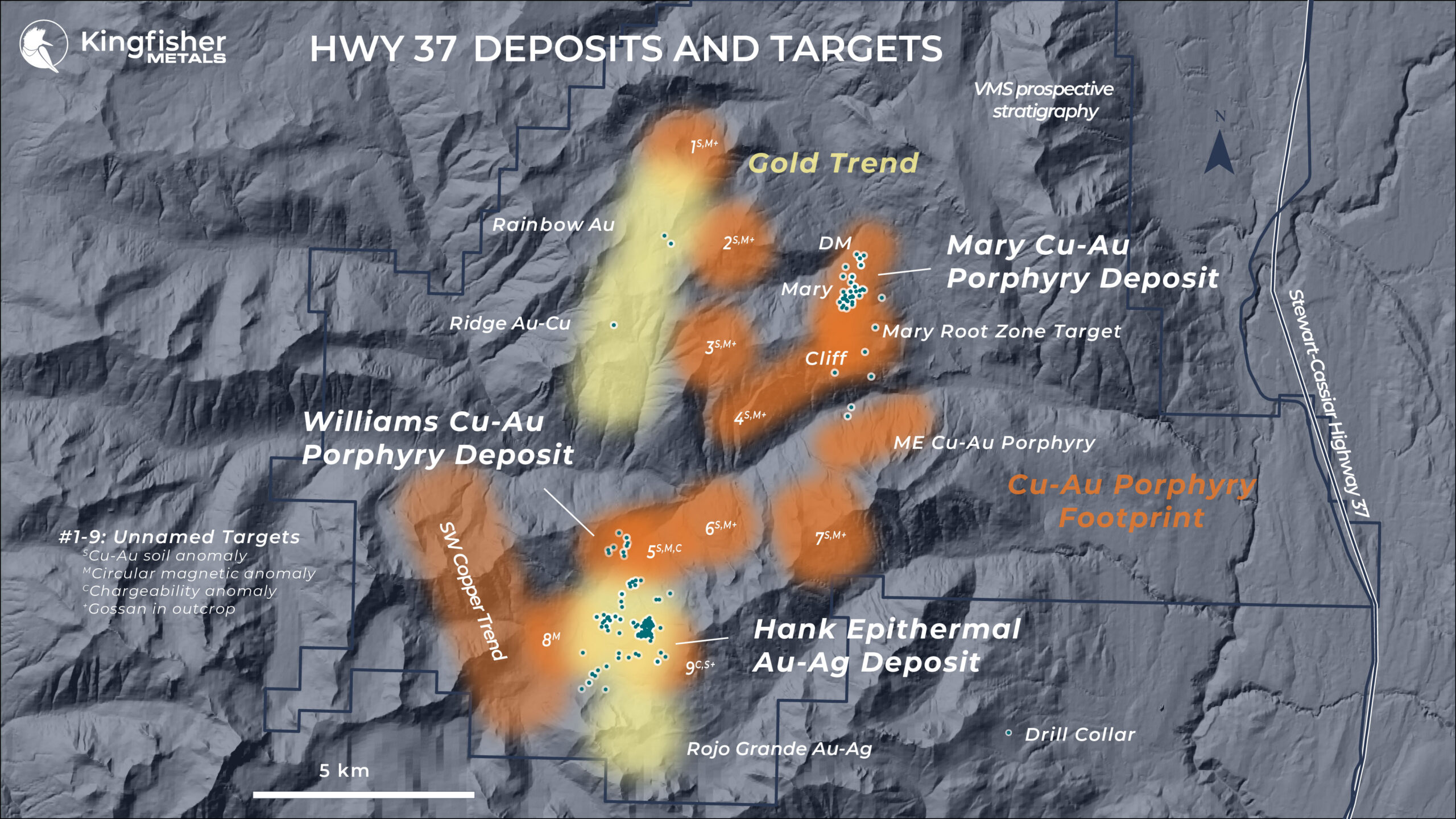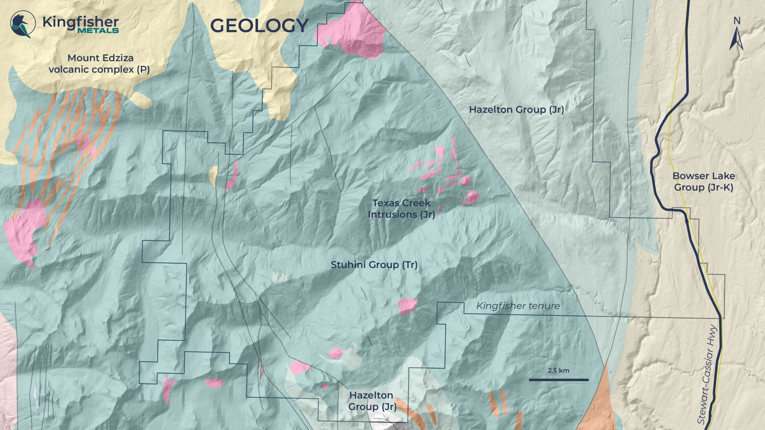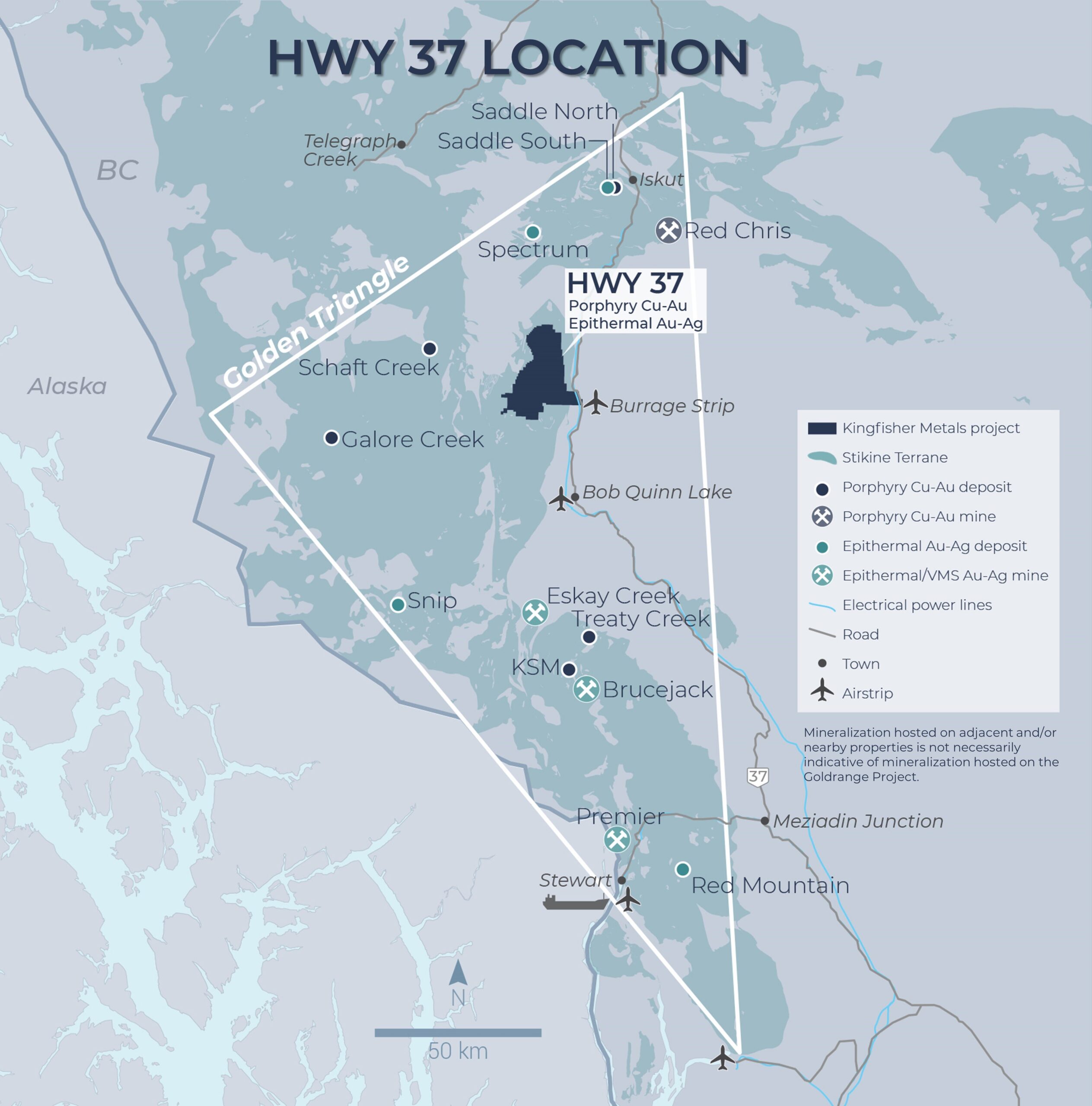
Targets
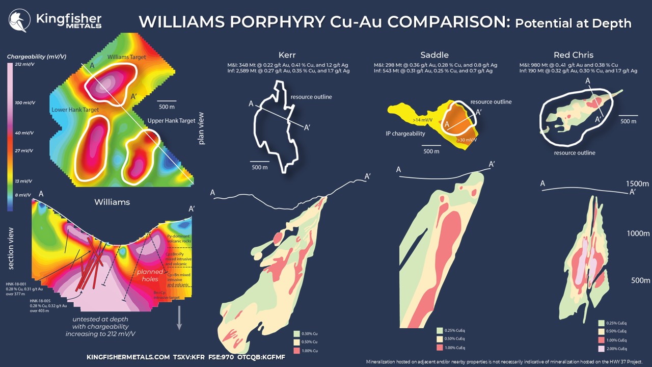
The Williams Cu-Au porphyry deposit (Minfile 104G 434) is highly prospective based on its analogous age to the nearby Mitchell deposits (4.1 Bt, 72.3 M oz Au, 11.9 B Lbs Cu; M&I contained resource)*, and that it is open laterally and at depth.
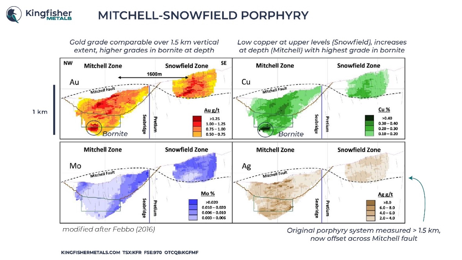
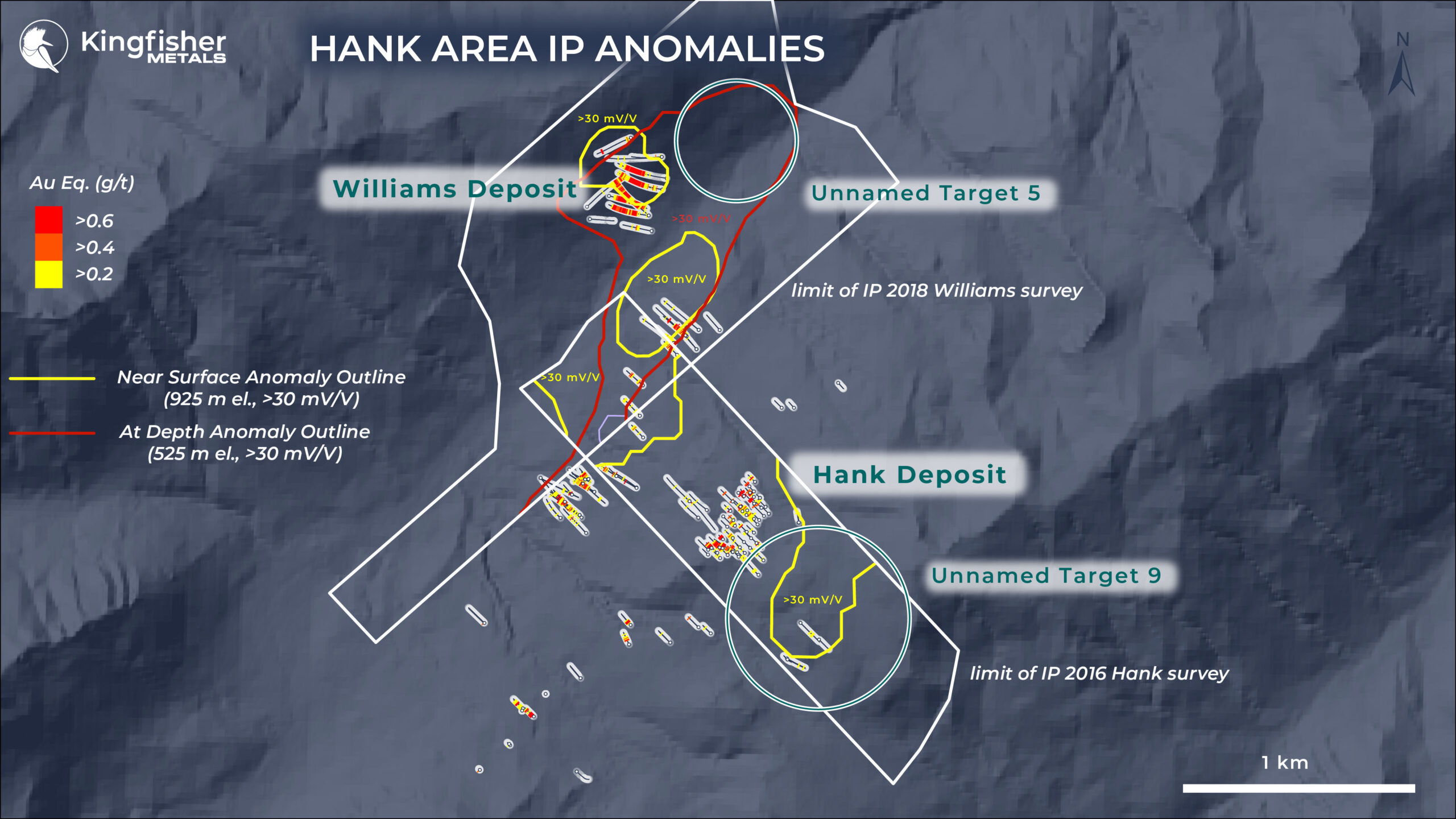
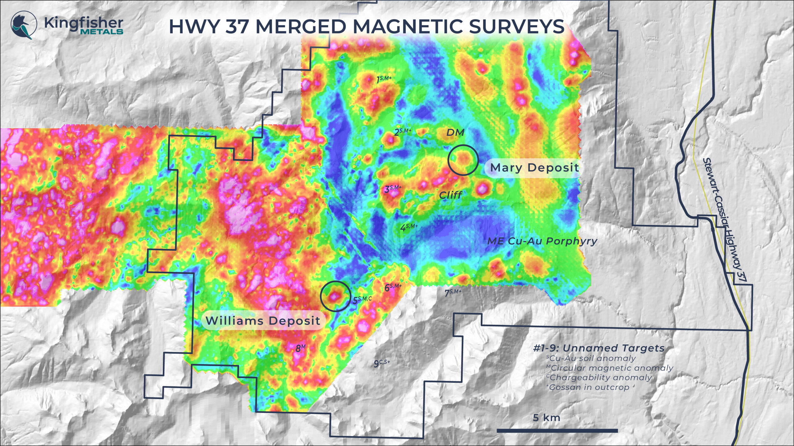
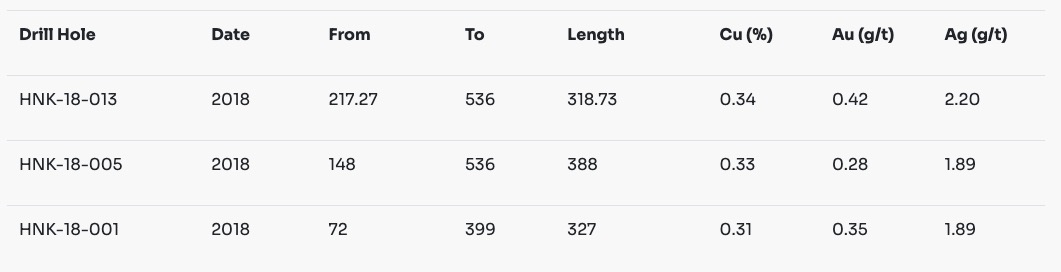
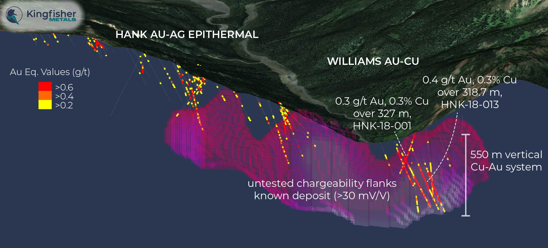
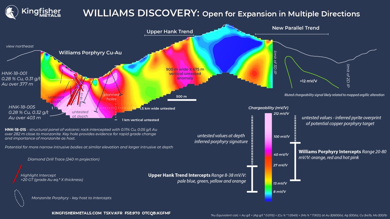
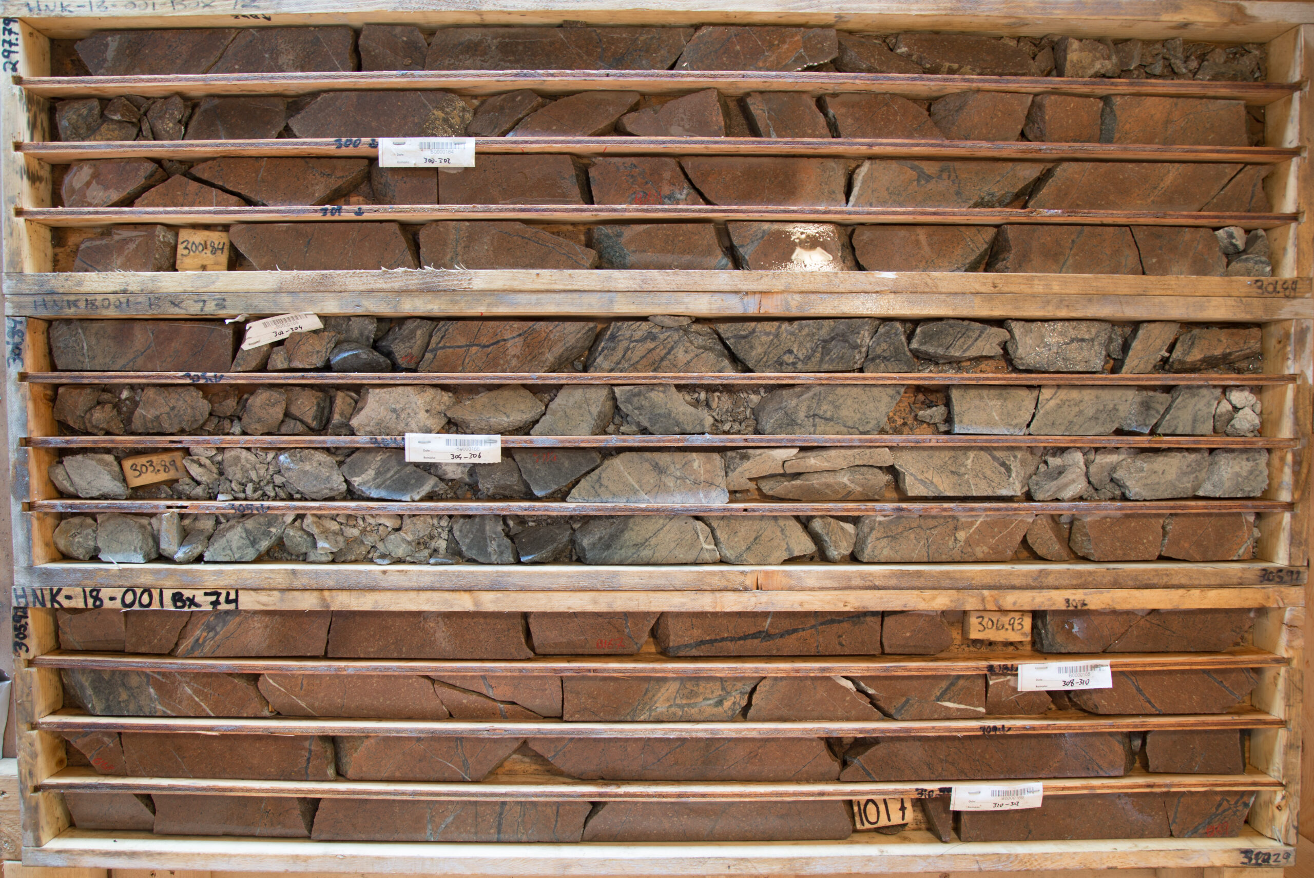
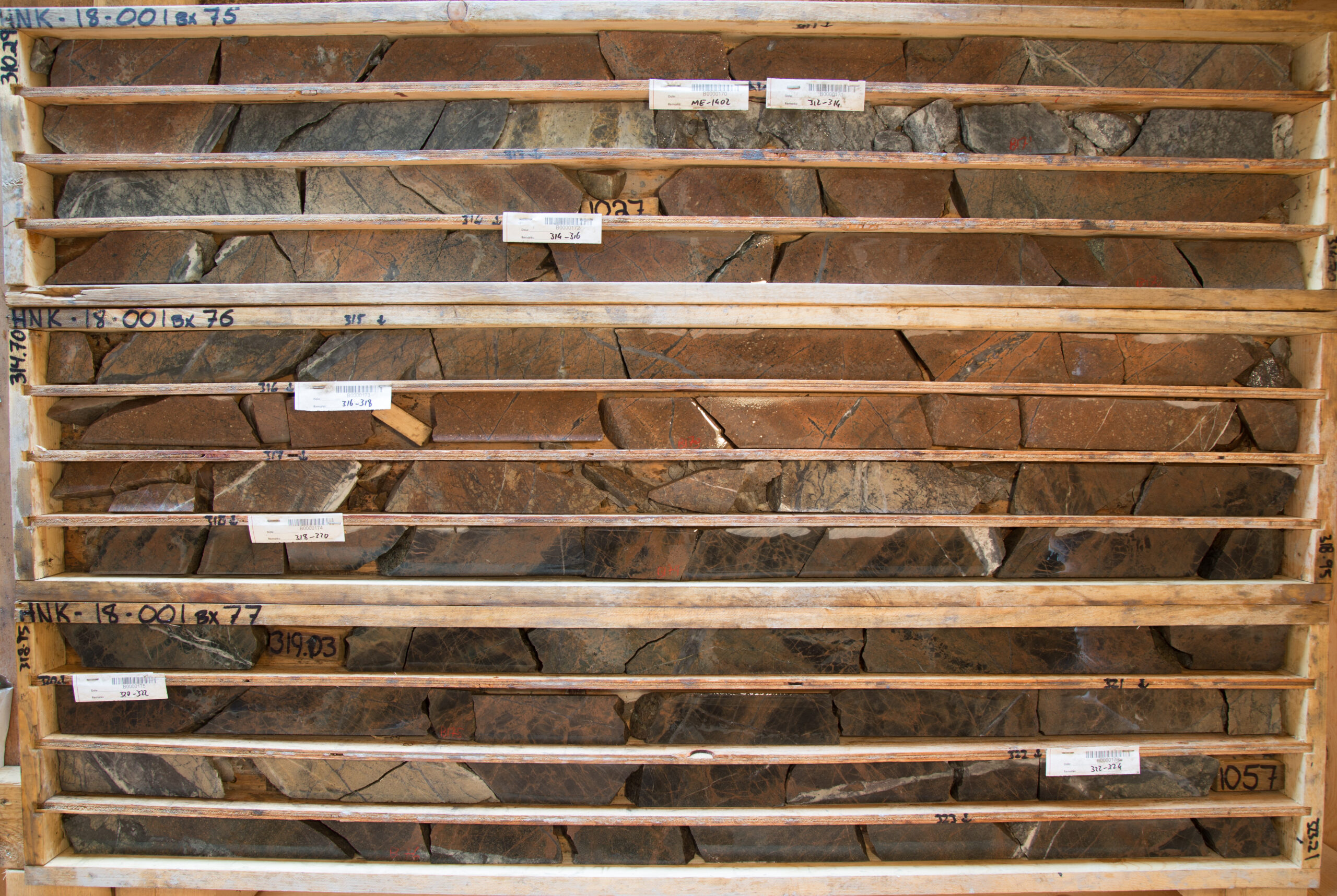
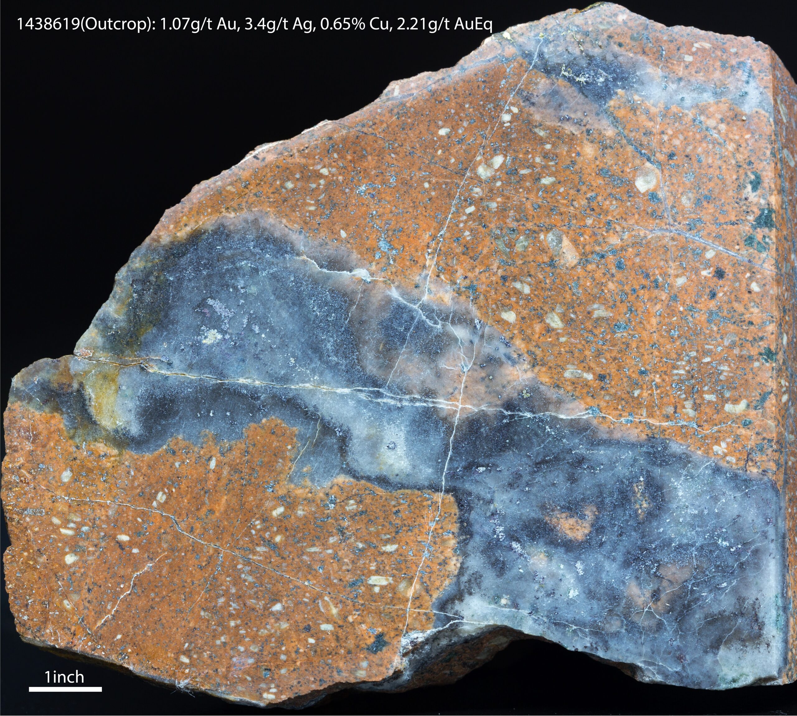
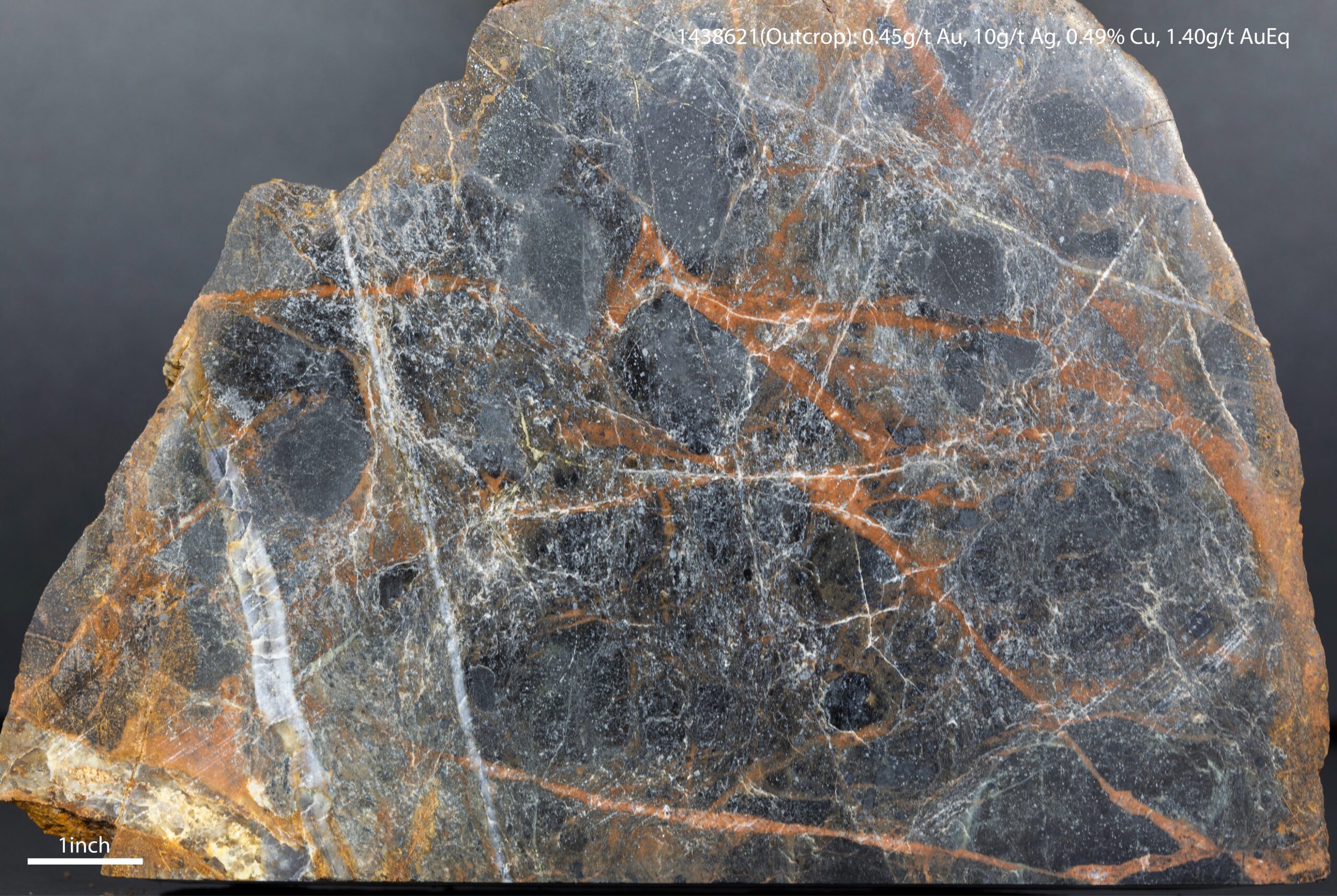
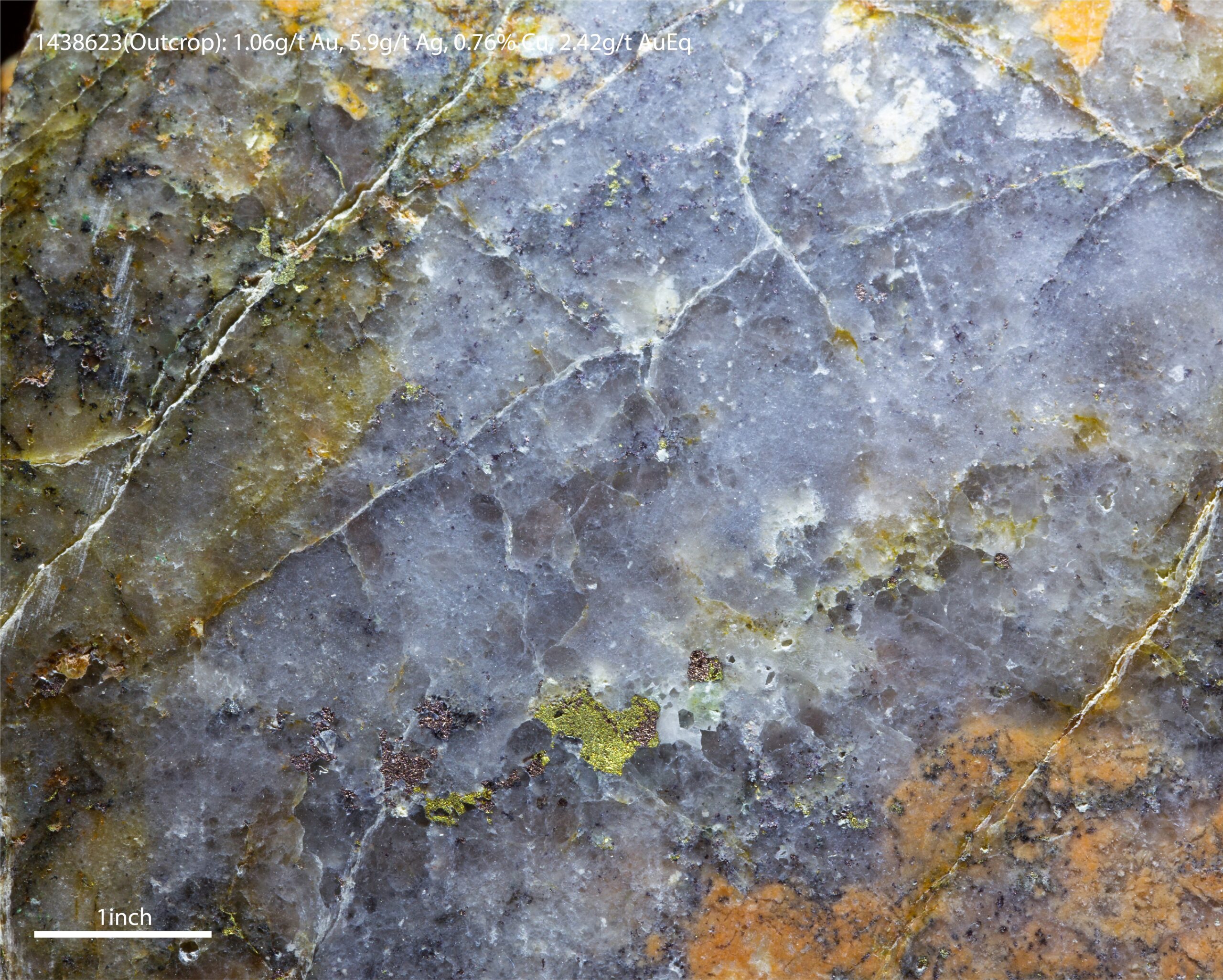
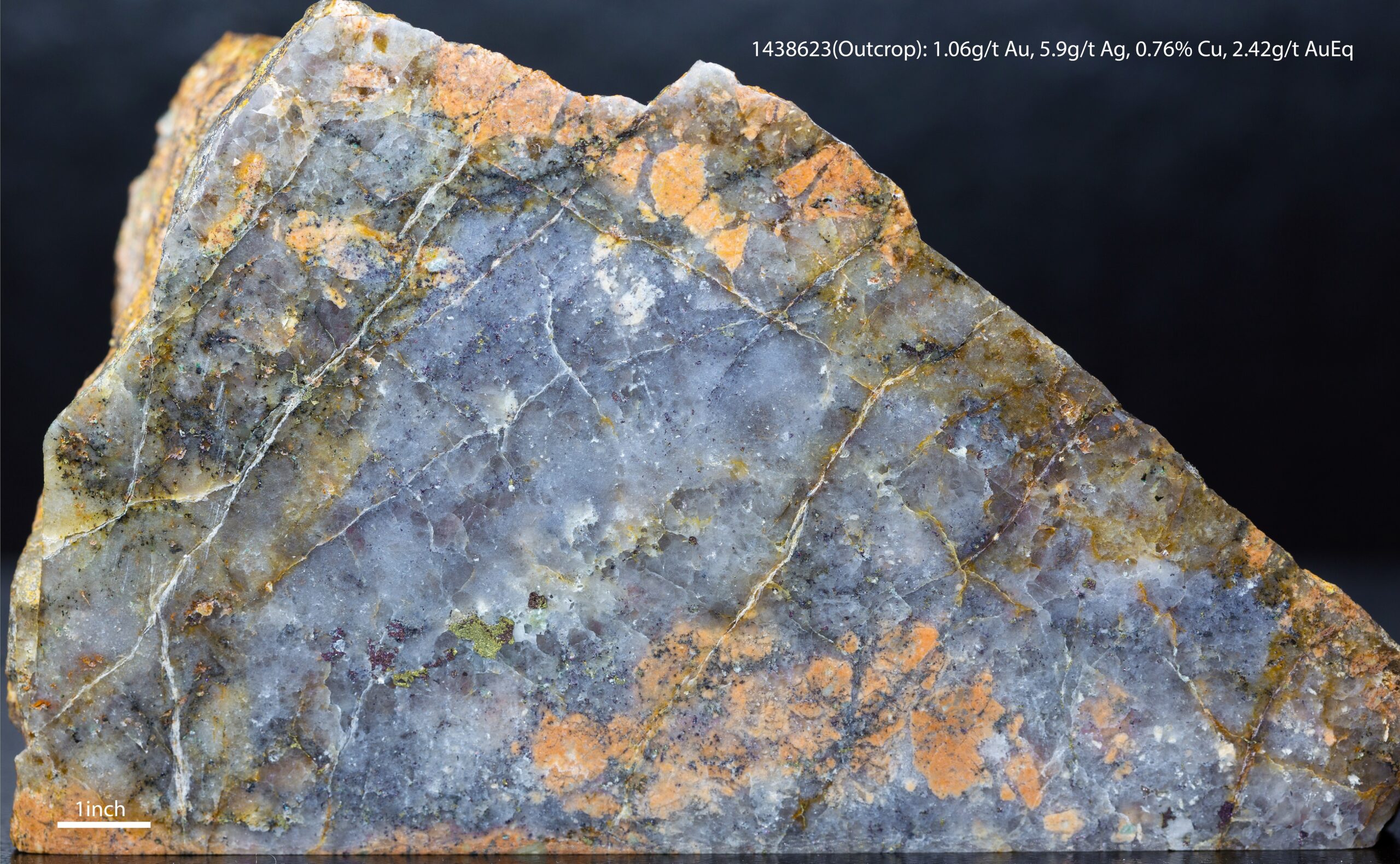
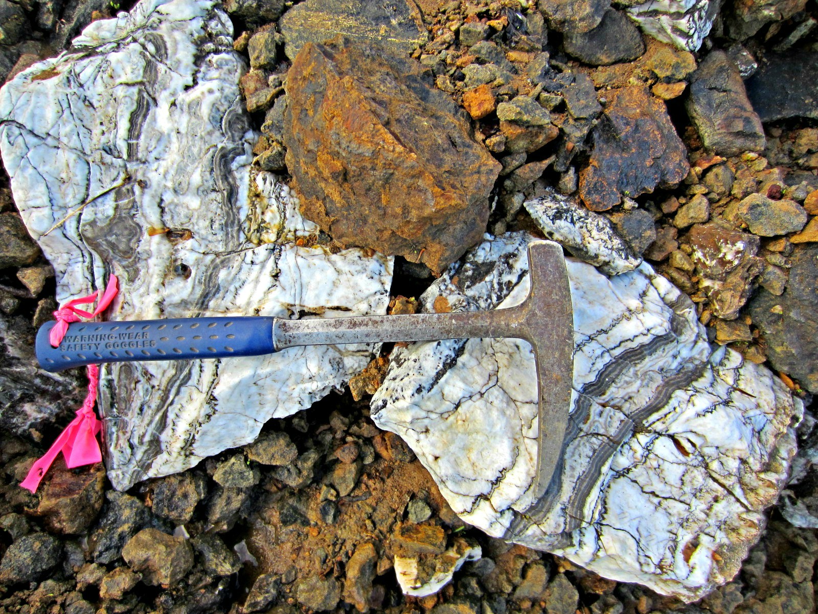
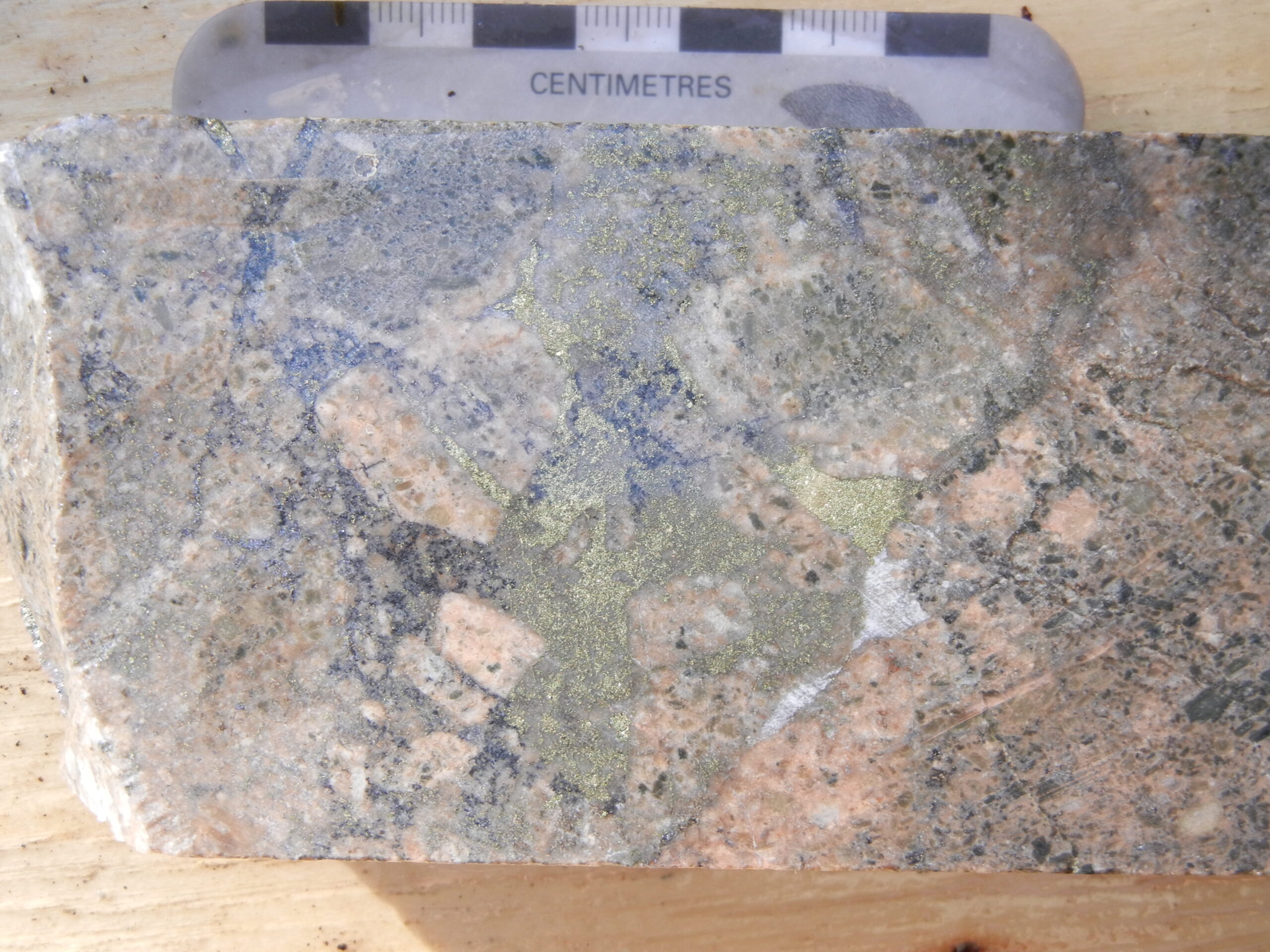
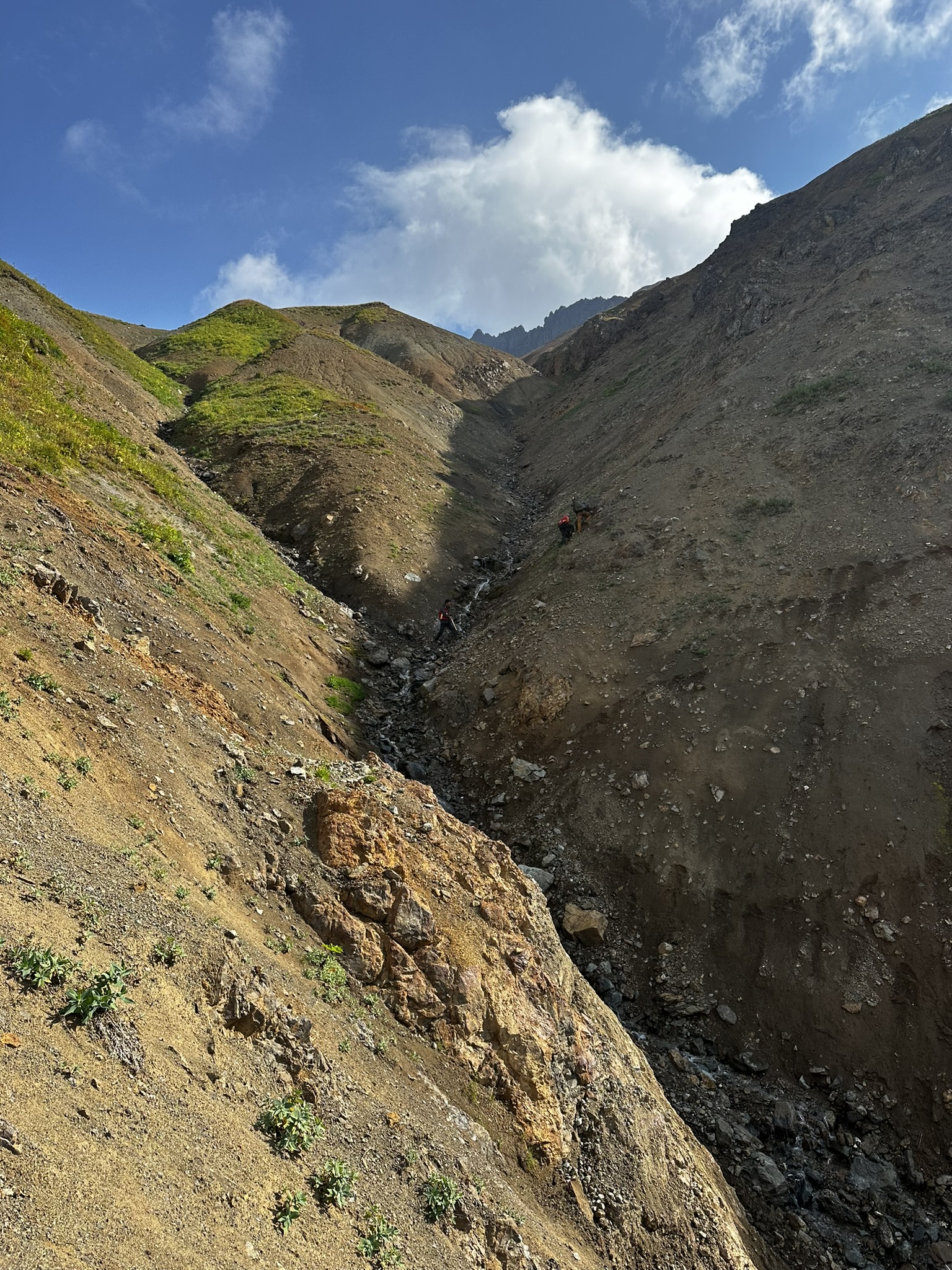
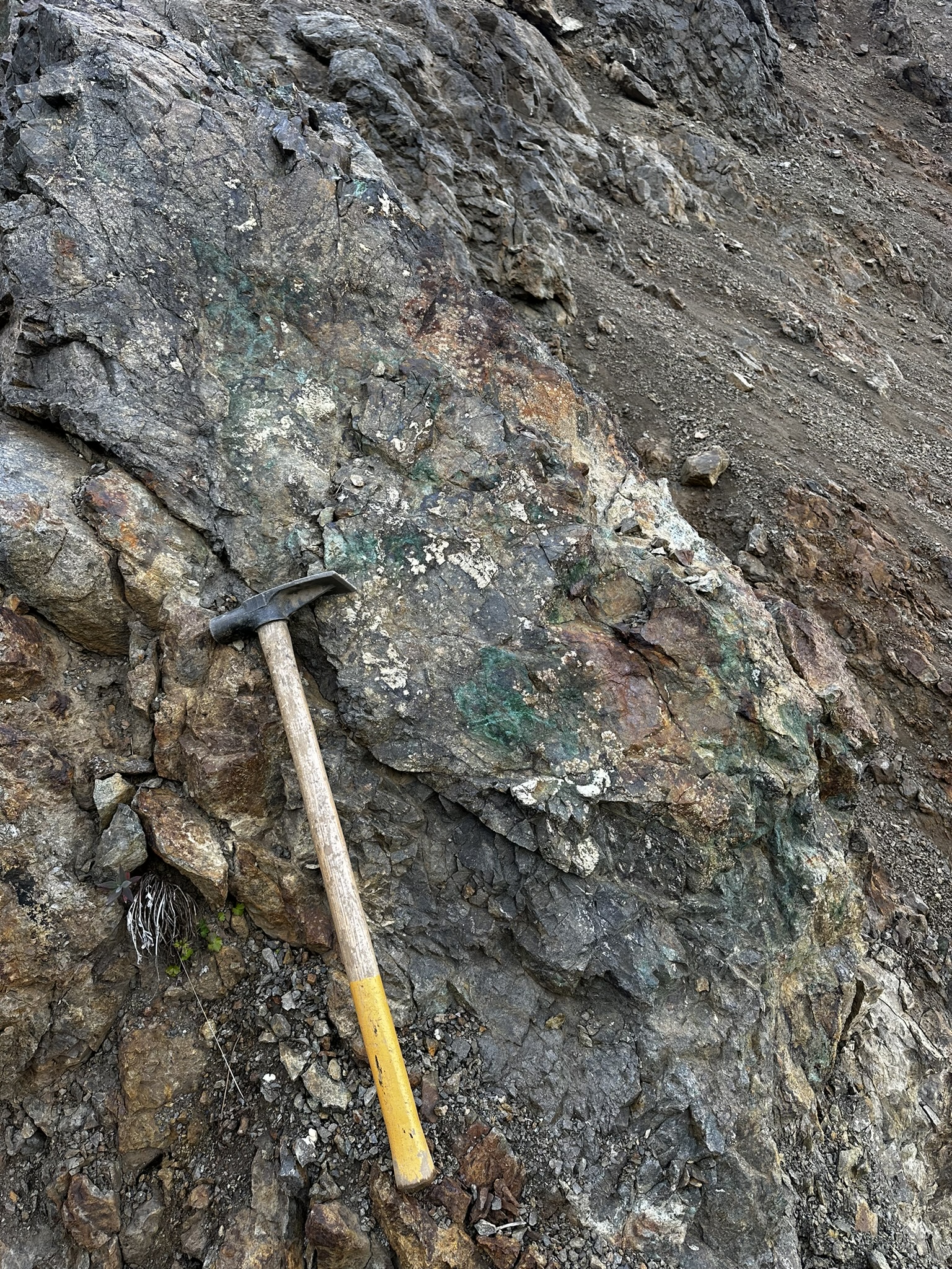
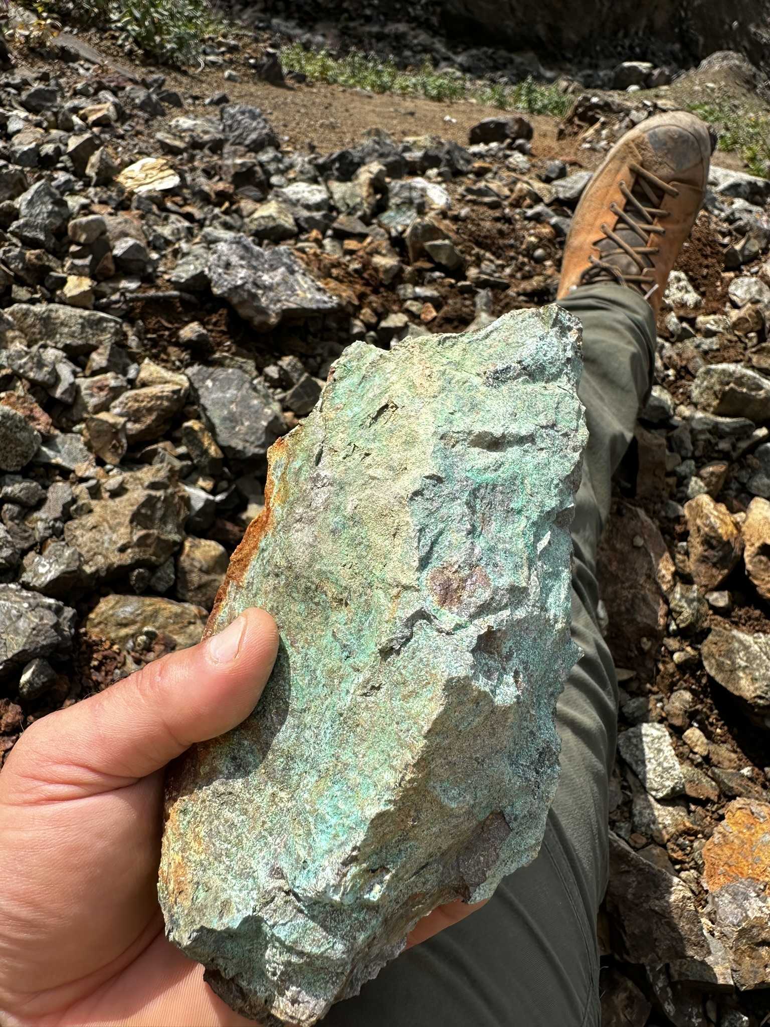
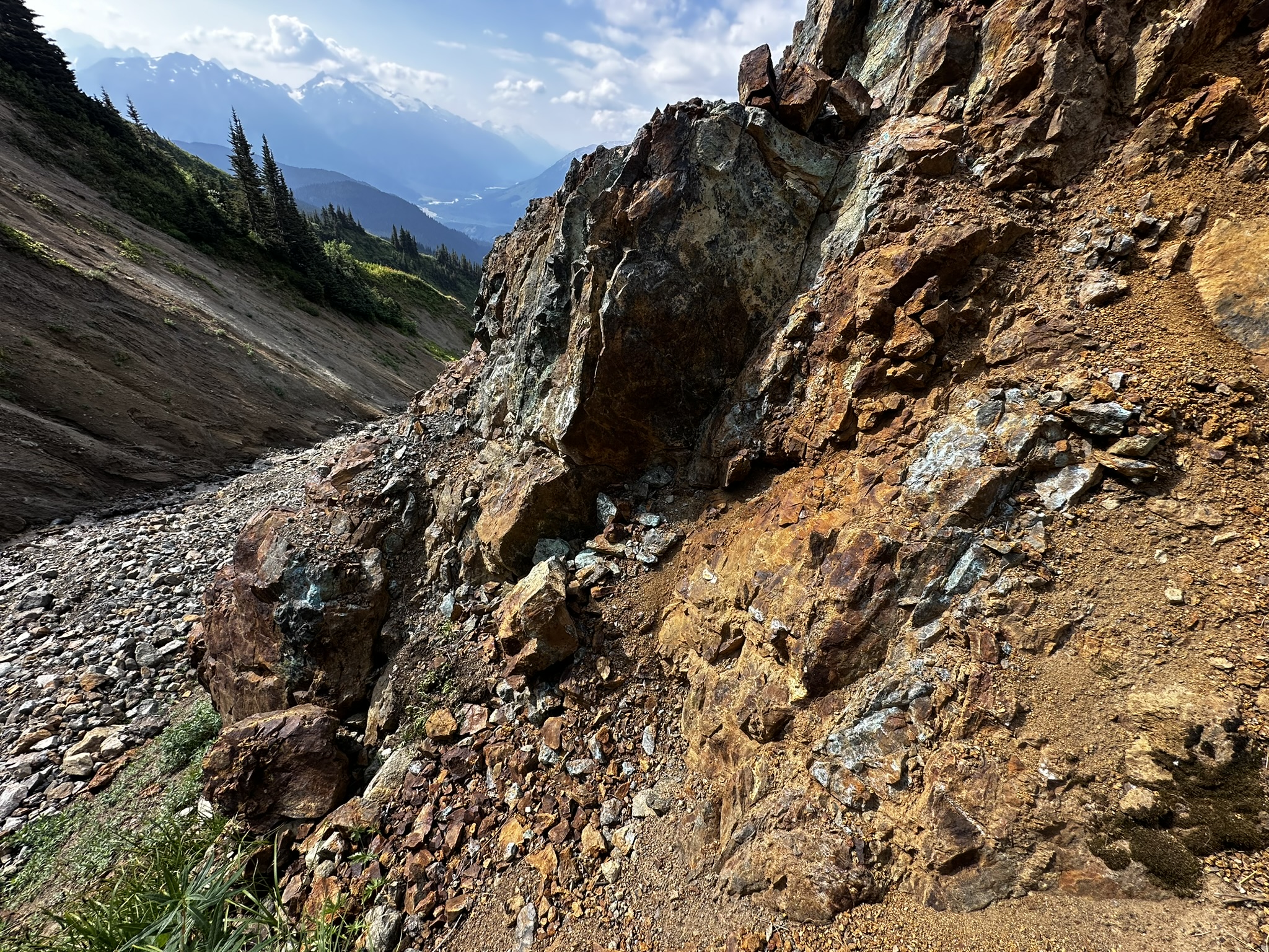
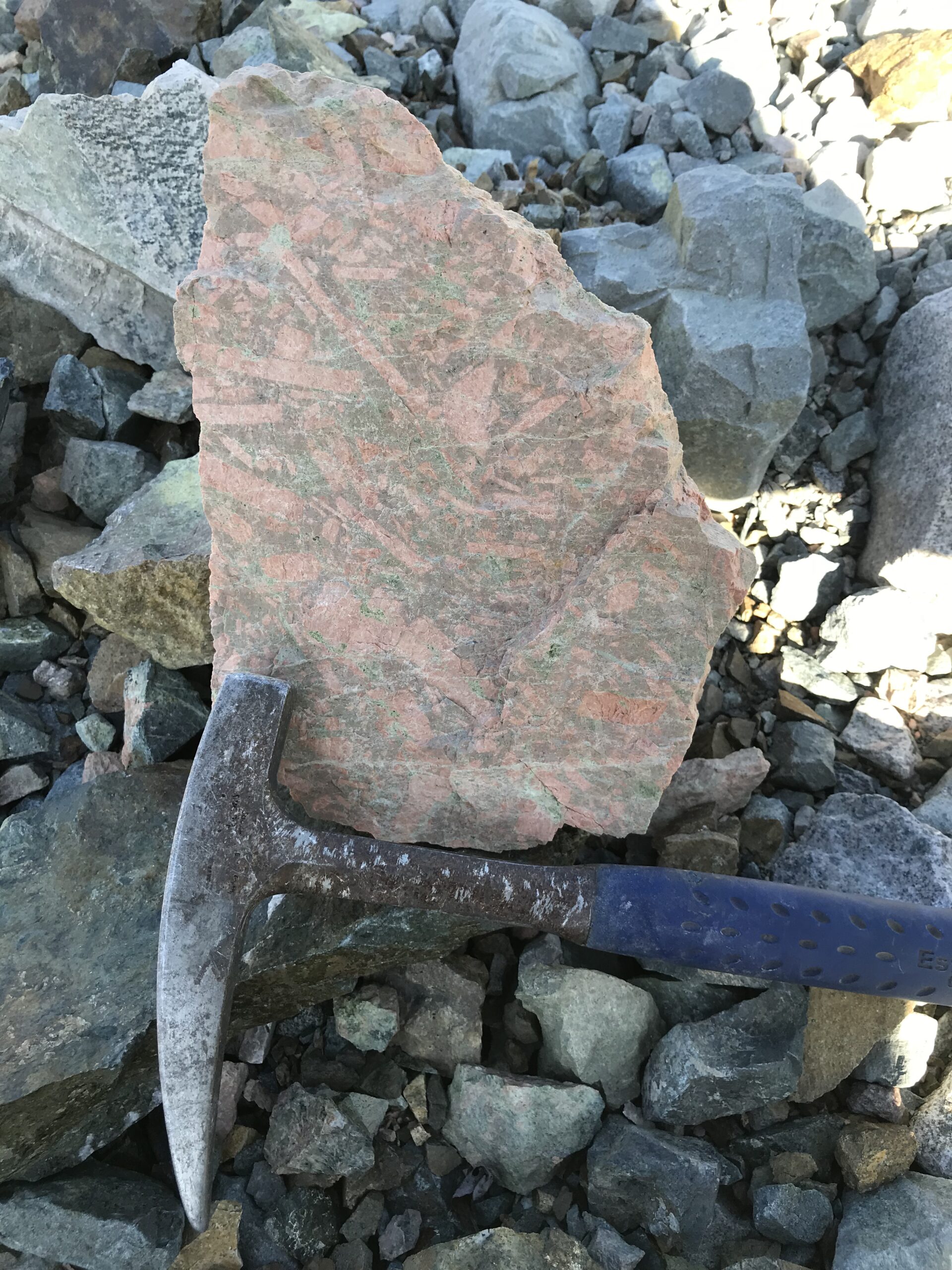
Williams was discovered in 2017 through prospecting and first drilled in 2018 with an initial drill hole returning 377 m of 0.31 g/t Au and 0.28% Cu (HNK-18-001). The deposit drill footprint of 500 m long by 400 m wide and 500-600 m deep is within a 2.2 km long and 1.5 km wide and 1 km deep chargeable body (>25 mV/V) with values up to 212 mV/V identified by the new survey. Intercepts at Williams coincide with potassic-altered monzonite porphyry intrusion that extend to surface with abrupt grade change between intrusive host and the volcanic rocks. The Williams deposit is largely hosted in one structurally focused intrusion within a chargeability anomaly that is prospective to host numerous such bodies.
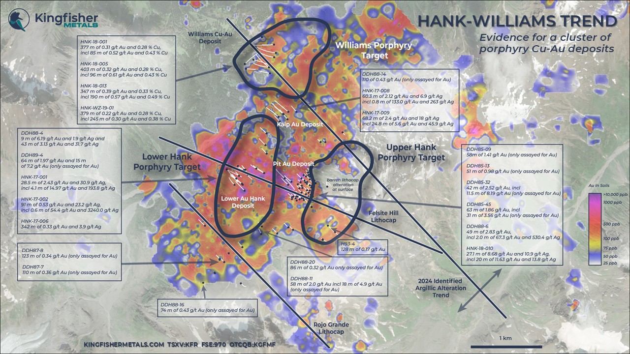
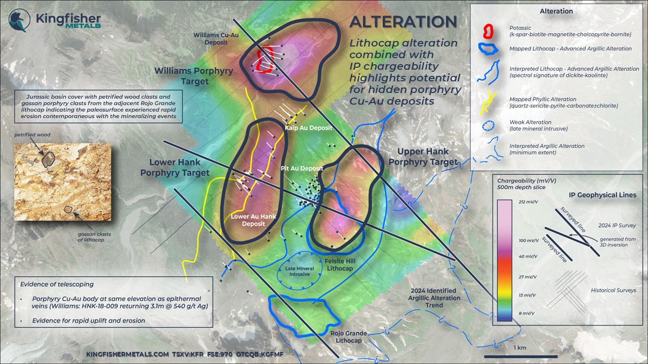
The upper-level porphyry target area includes domains to the north and south of the Williams deposit and are interpreted as structurally-controlled, Williams-like stocks, such as 190 m of 0.49% Cu, and 0.57 g/t Au (HNK-18-13). The deeper target domain spans 1 km wide and includes the peak chargeability values (212 mV/V) where there is potential for more broad, intrusive-hosted stockwork. From regional examples, highest relative copper grades are associated with bornite typically intercepted at deeper levels where higher temperature conditions exist. The geometry of chargeability supports this exploration concept with a marked chargeable high close to surface in volcanic rocks (pyrite>chalcopyrite), a muted mid-level response in mixed intrusions and volcanic rocks (chalcopyrite>pyrite), and a broadening root zone where bornite>chalcopyrite is conceptualized in an intrusive host. Given the grade at Williams and the significant scale of the anomaly, this target area has been elevated to a top priority.
*The Company notes that mineralization on nearby projects is not indicative of mineralization on the HWY 37 and LGM projects.
Drill Hole | From (m) | To (m) | Interval (m) | Au g/t | Cu % | Ag g/t |
HNK-18-001 | 36.0 | 413.0 | 377.0 | 0.31 | 0.28 | 1.75 |
Including | 97.0 | 182.0 | 85.0 | 0.52 | 0.44 | 3.16 |
HNK-18-002 | 116.0 | 416.0 | 300.0 | 0.22 | 0.29 | 2.20 |
HNK-18-005 | 148.0 | 550.8 | 402.8 | 0.32 | 0.28 | 1.84 |
Including | 148.0 | 244.0 | 96.0 | 0.61 | 0.43 | 2.56 |
HNK-18-007 | 366.0 | 603.5 | 237.5 | 0.17 | 0.18 | 2.01 |
HNK-18-013 | 217.3 | 564.0 | 346.7 | 0.39 | 0.33 | 2.06 |
Including | 217.3 | 407.0 | 189.7 | 0.57 | 0.49 | 2.78 |
Including | 275.0 | 401.9 | 126.9 | 0.69 | 0.56 | 3.37 |
HNK-18-015 | 393.6 | 512.0 | 118.4 | 0.06 | 0.14 | 0.82 |
HNK-WZ-19-01 | 233.0 | 611.5 | 378.5 | 0.22 | 0.28 | 1.44 |
Including | 272.0 | 517.0 | 245.0 | 0.30 | 0.38 | 1.84 |
Williams Drill Highlights
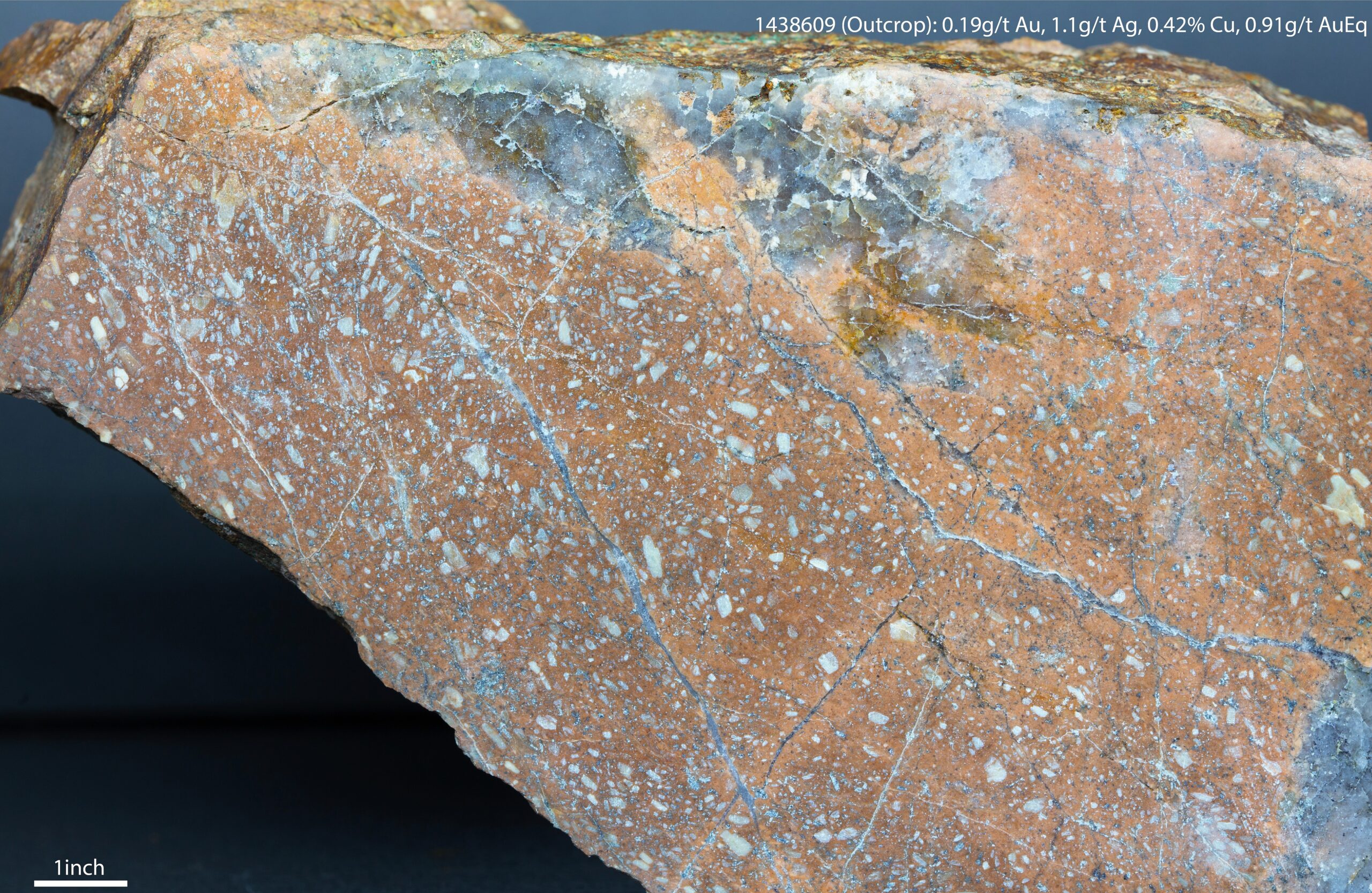
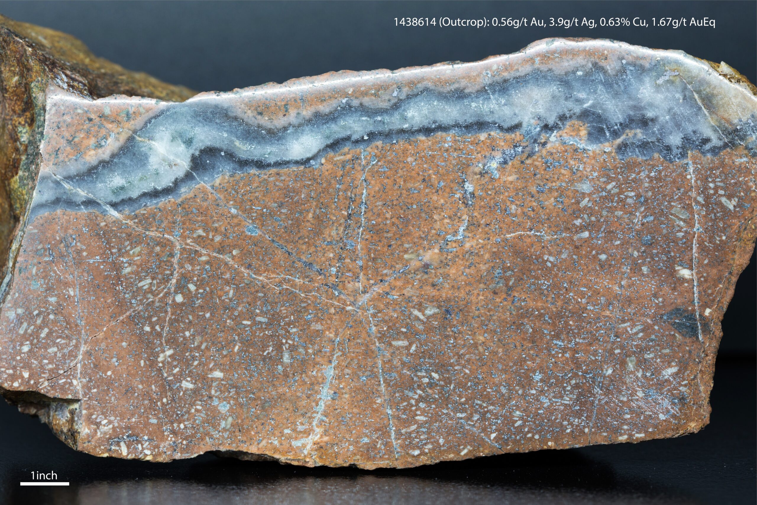
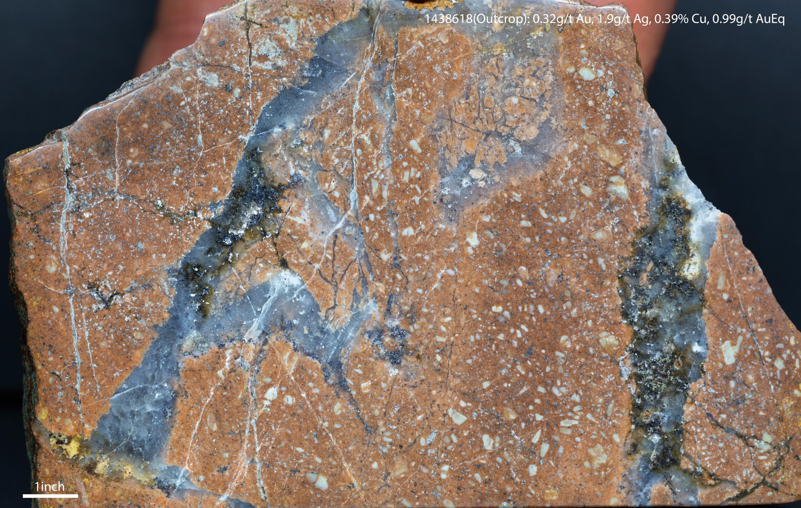
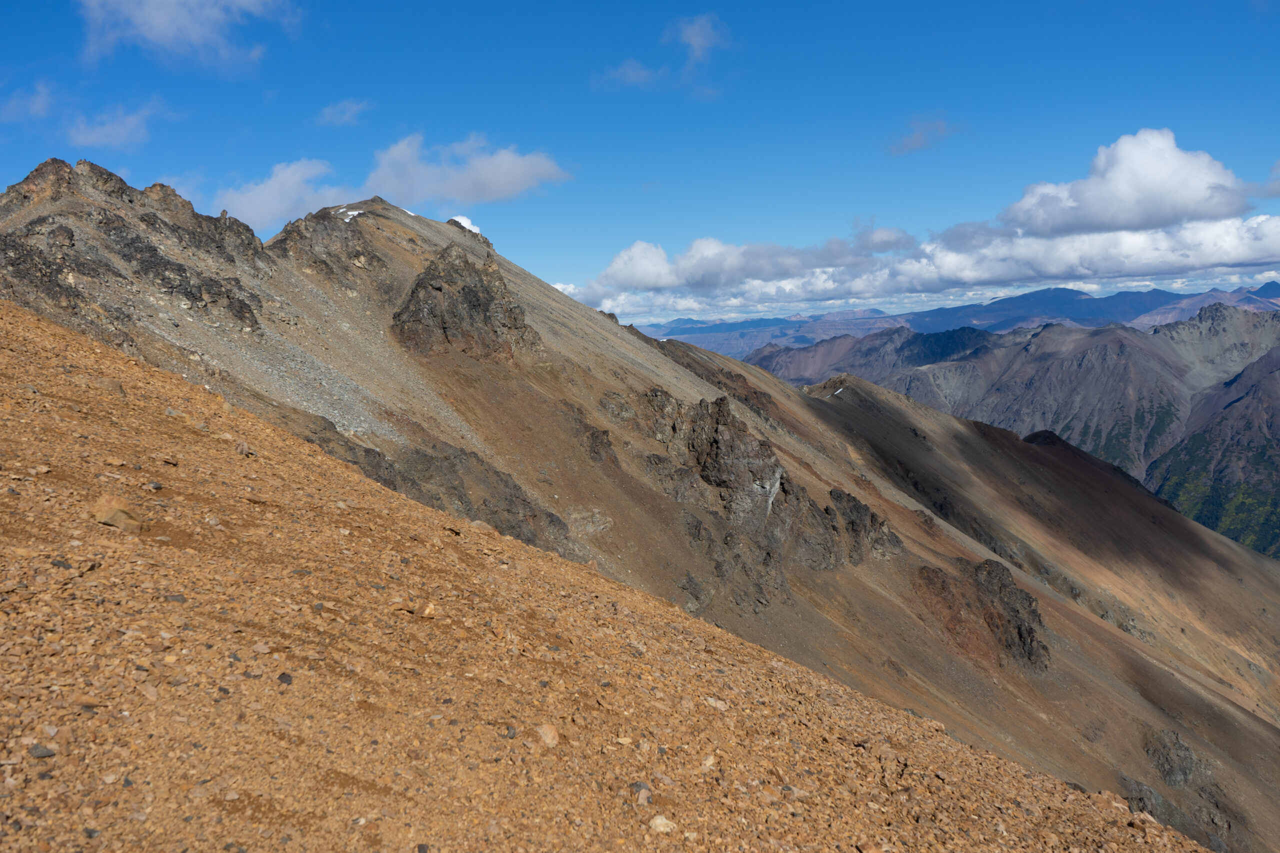
Gallery

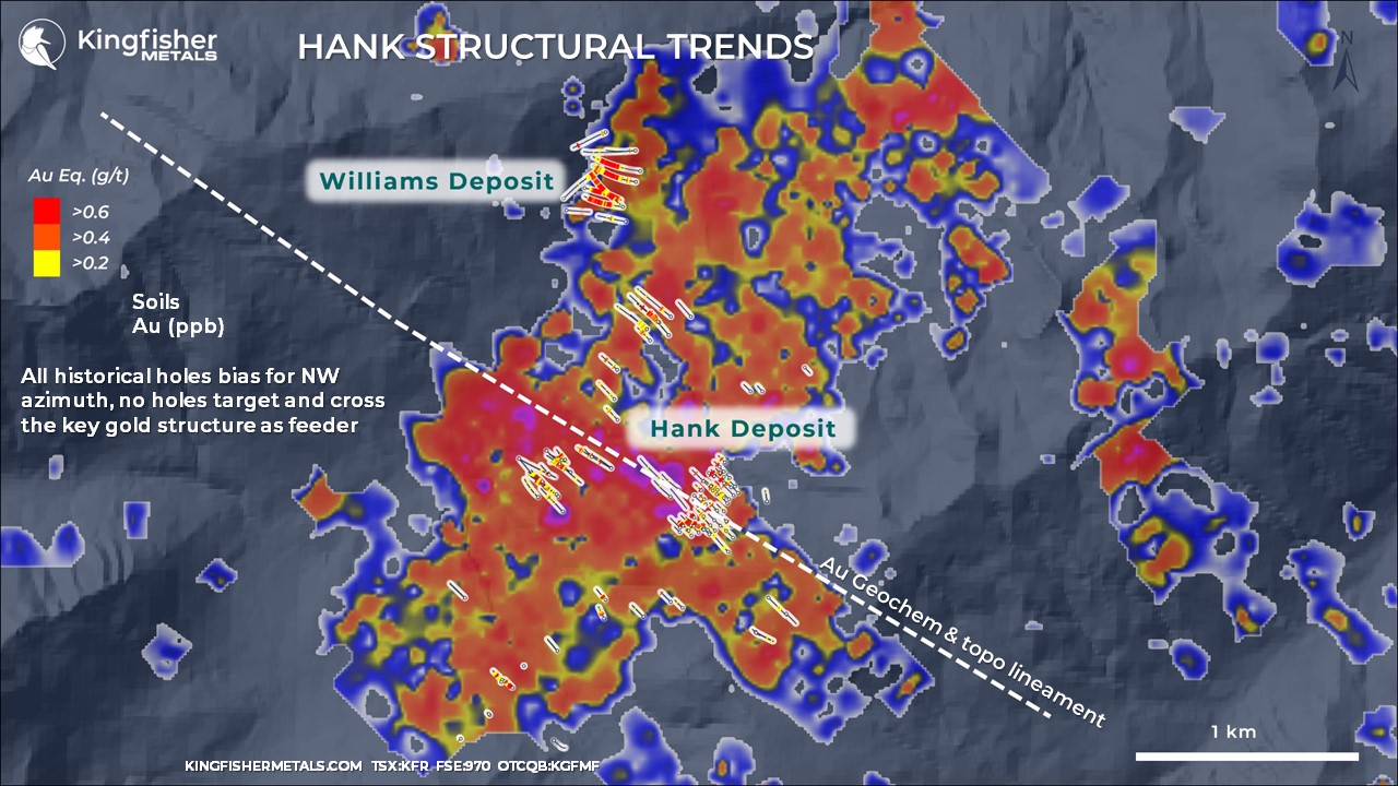
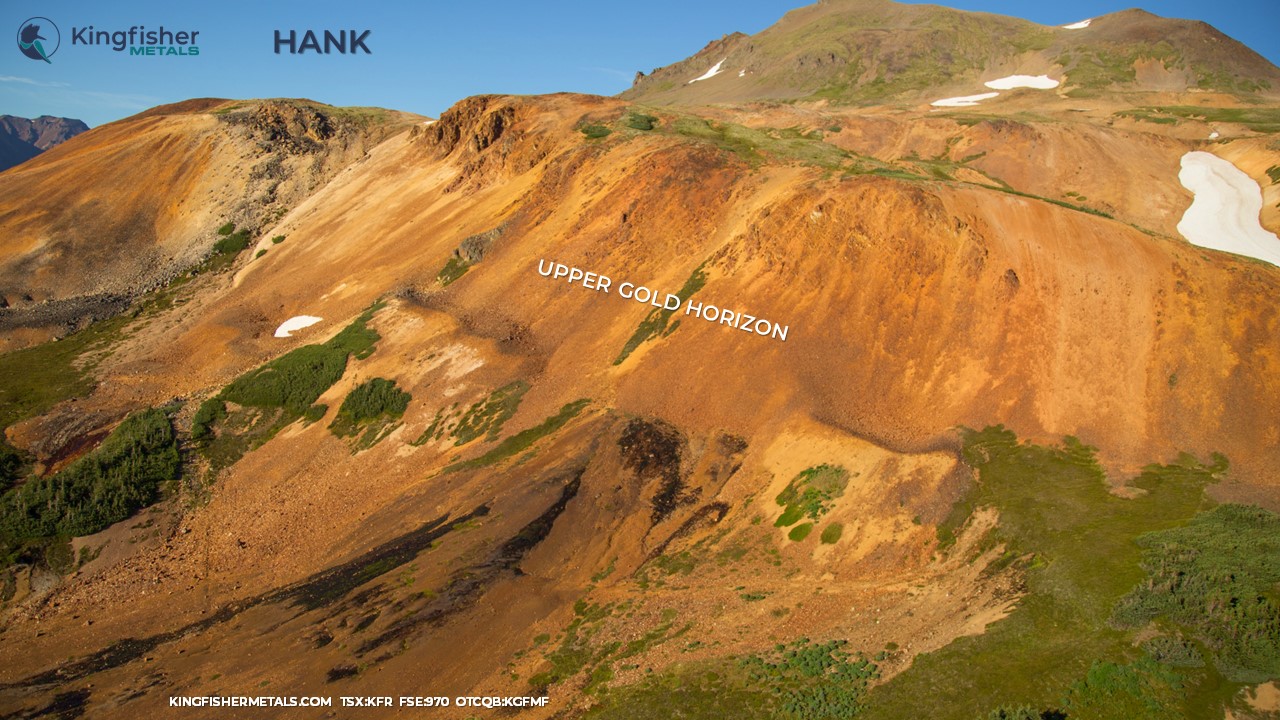
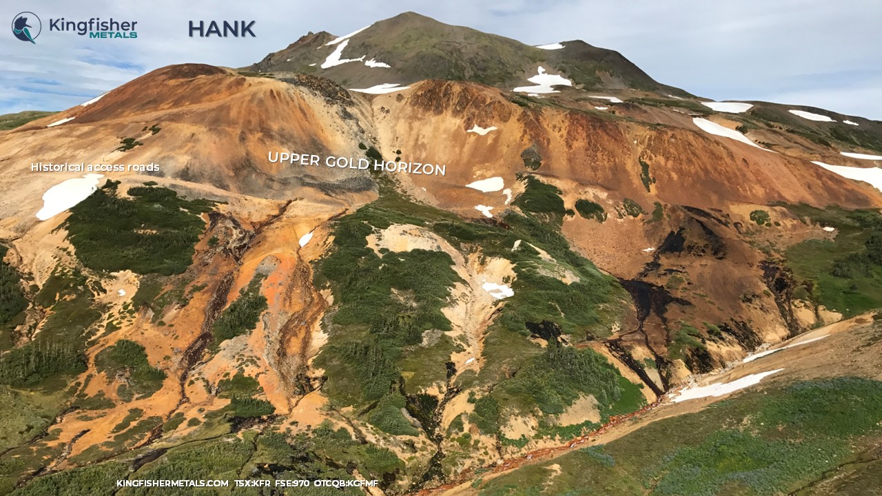
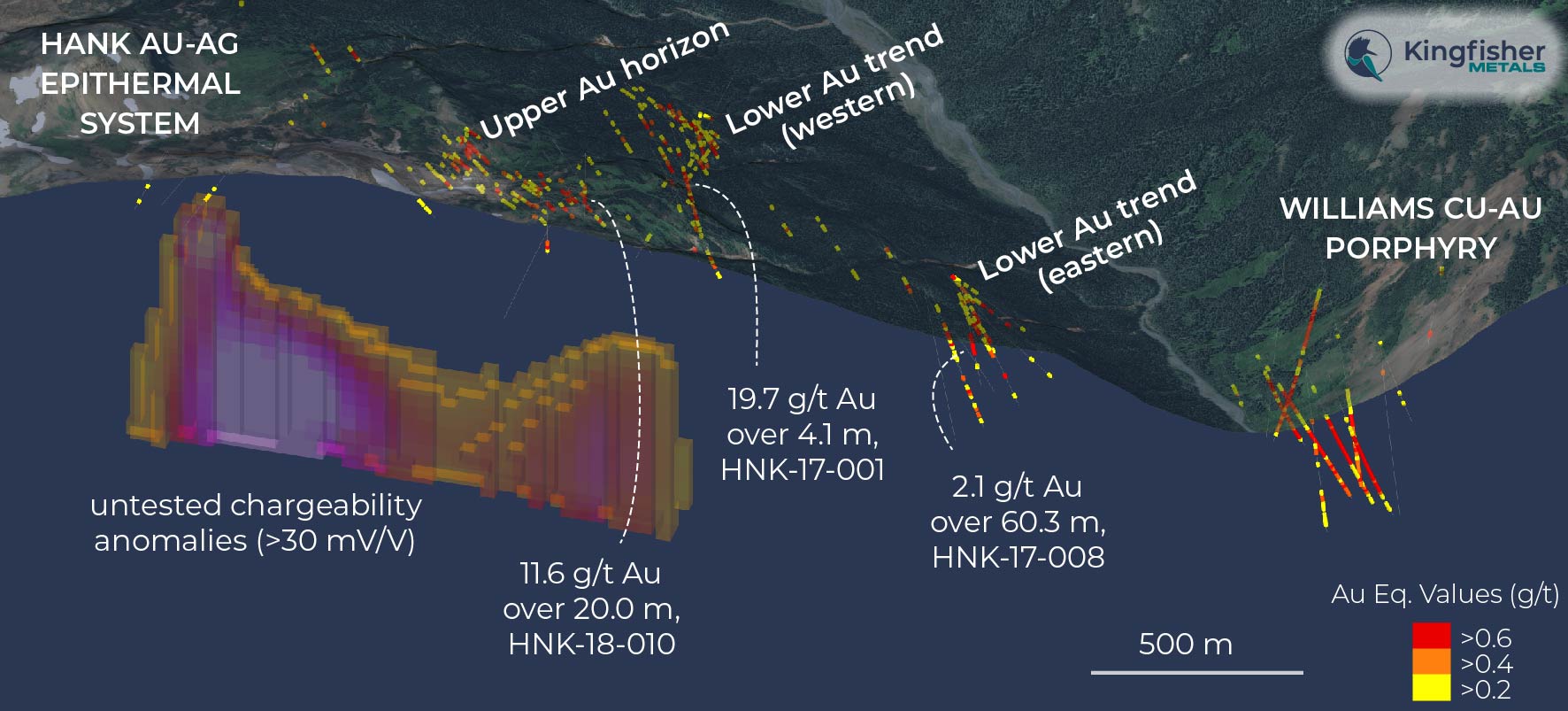
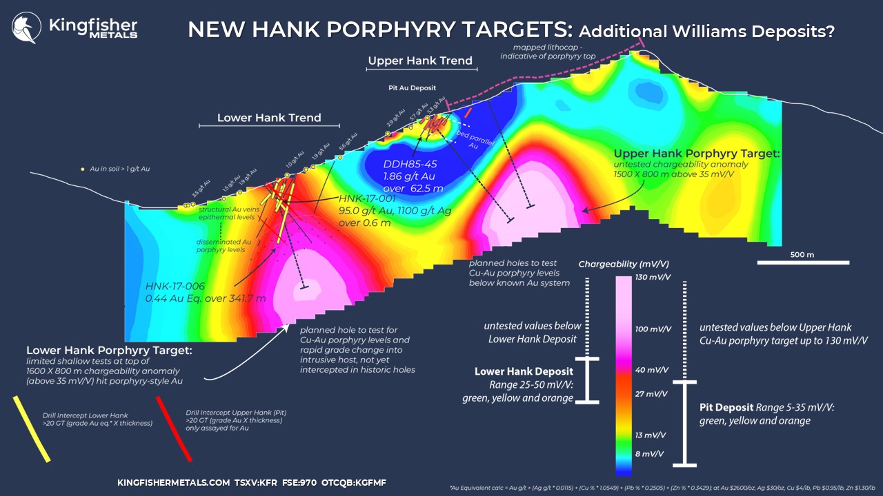
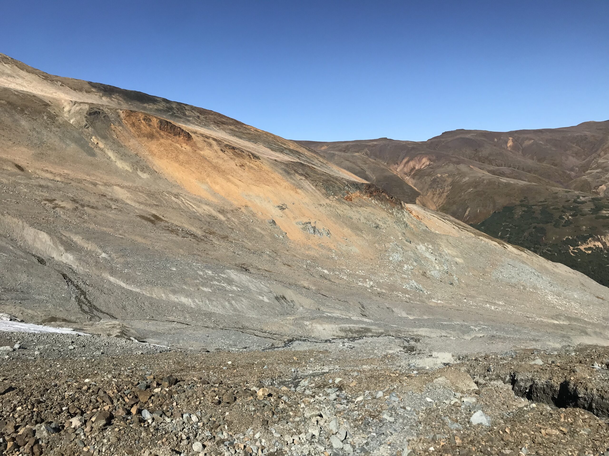
The upper levels of alteration of the historical epithermal Hank Au-Ag district (Minfile 104G 107) are now considered to be a hybrid alteration expression of an early porphyry and late epithermal system. Evidence of a cryptic early porphyry emplacement is provided by a large ‘advanced argillic’ alteration assemblage of dickite-kaolinite-quartz-pyrite mapped on surface and confirmed by a spectral study. These minerals commonly lie directly above Cu-Au porphyry deposits as part of a ‘lithocap’ or porphyry top. A new 3D IP inversion product from coupled historical and 2024 lines revealed a 1.5 km long by 0.8 km wide and 850 m deep (>35 mV/V) anomaly seated below this porphyry top.
The large anomaly at Upper Hank is comparable in size, vertical emplacement level and geometry to the chargeability body at the nearby Williams porphyry deposit and is considered to be highly prospective for a new porphyry discovery. Three target domains exist at the Upper Hank: 1) the projection of at-surface, bed parallel epithermal gold mineralization at the Pit deposit (intermediate sulfidation, e.g., 20 m of 11.63 g/t Au and 13.8 g/t Ag and 63 m of 1.86 g/t Au); 2) disseminated gold-rich or gold-only target from surface in the area of the lithocap above the anomaly (high sulfidation); and 3) intrusive-hosted porphyry Cu-Au in upper-level stocks from ~350 m drill depths below at-surface gold targets. The Upper Hank Porphyry target provides a unique opportunity to drill both high-grade gold targets and porphyry Cu-Au targets with a single hole.


Drill Hole | From (m) | To (m) | Interval (m) | Au g/t | Ag g/t | Cu % | Pb % | Zn % |
DDH84-2 | 4.3 | 42.5 | 38.3 | 0.89 |
|
|
|
|
DDH84-4 | 2.1 | 57.9 | 55.8 | 1.38 |
|
|
|
|
Including | 36.3 | 44.2 | 8.0 | 6.74 | 12.14 |
|
|
|
DDH85-04 | 57.5 | 91.4 | 33.9 | 2.55 |
|
|
|
|
Including | 74.0 | 75.5 | 1.5 | 46.66 |
|
|
|
|
DDH85-05 | 91.5 | 99.4 | 7.9 | 2.27 |
|
|
|
|
DDH85-06 | 67.0 | 115.5 | 47.0 | 0.58 |
|
|
|
|
DDH85-08 | 24.5 | 62.0 | 37.5 | 0.54 |
|
|
|
|
DDH85-09 | 7.0 | 62.8 | 55.8 | 1.47 |
|
|
|
|
Including | 42.0 | 62.8 | 20.8 | 3.22 |
|
|
|
|
DDH85-10 | 7.5 | 21.0 | 13.5 | 2.32 |
|
|
|
|
DDH85-13 | 5.0 | 56.4 | 51.4 | 0.98 |
|
|
|
|
DDH85-15 | 82.5 | 98.0 | 15.5 | 1.02 |
|
|
|
|
DDH85-16 | 26.0 | 97.0 | 71.0 | 0.35 |
|
|
|
|
DDH85-30 | 7.0 | 100.0 | 93.0 | 0.22 |
|
|
|
|
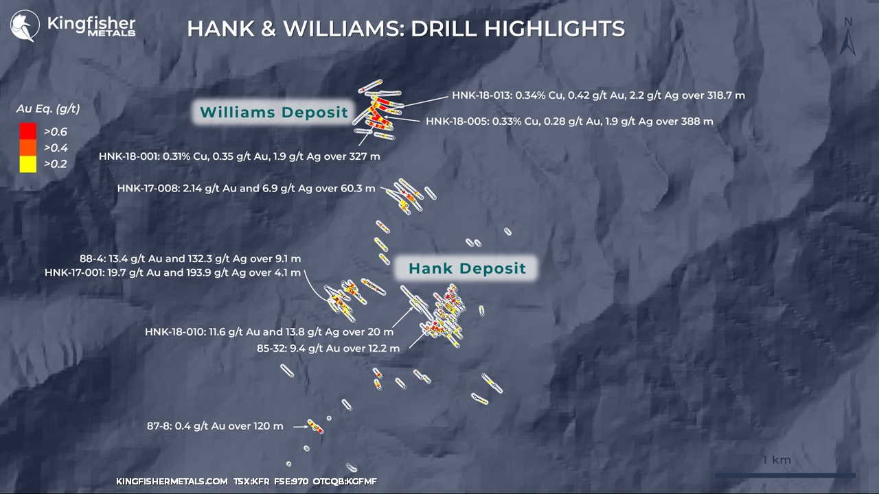
DDH85-32 | 6.0 | 47.5 | 41.5 | 2.52 |
|
|
|
|
Inlcuding | 25.5 | 37.0 | 11.5 | 8.19 |
|
|
|
|
DDH85-35 | 17.0 | 84.4 | 67.4 | 0.32 |
|
|
|
|
DDH85-39 | 26.5 | 93.0 | 66.5 | 0.39 |
|
|
|
|
DDH85-40 | 8.5 | 49.7 | 41.2 | 0.49 |
|
|
|
|
DDH85-42 | 0.0 | 61.0 | 61.0 | 0.35 |
|
|
|
|
DDH85-45 | 35.0 | 97.5 | 62.5 | 1.86 |
|
|
|
|
Including | 35.0 | 66.0 | 31.0 | 3.56 |
|
|
|
|
DDH87-1 | 42.5 | 69.5 | 27.0 | 0.83 |
|
|
|
|
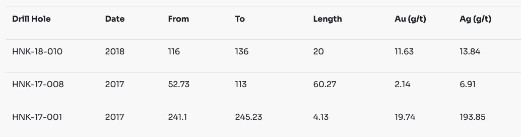
HNK-18-010 | 114.5 | 141.6 | 27.1 | 8.68 | 10.87 | 0.00 | 0.00 | 0.02 |
Including | 116.0 | 136.0 | 20.0 | 11.63 | 13.84 | 0.01 | 0.00 | 0.02 |
Including | 116.0 | 118.9 | 2.9 | 67.27 | 74.12 | 0.03 | 0.02 | 0.09 |
DDH90-5 | 76.5 | 123.6 | 47.1 | 0.57 | 2.39 | 0.00 | 0.00 | 0.01 |
DDH88-6 | 374.5 | 423.4 | 48.9 | 2.83 |
|
|
|
|
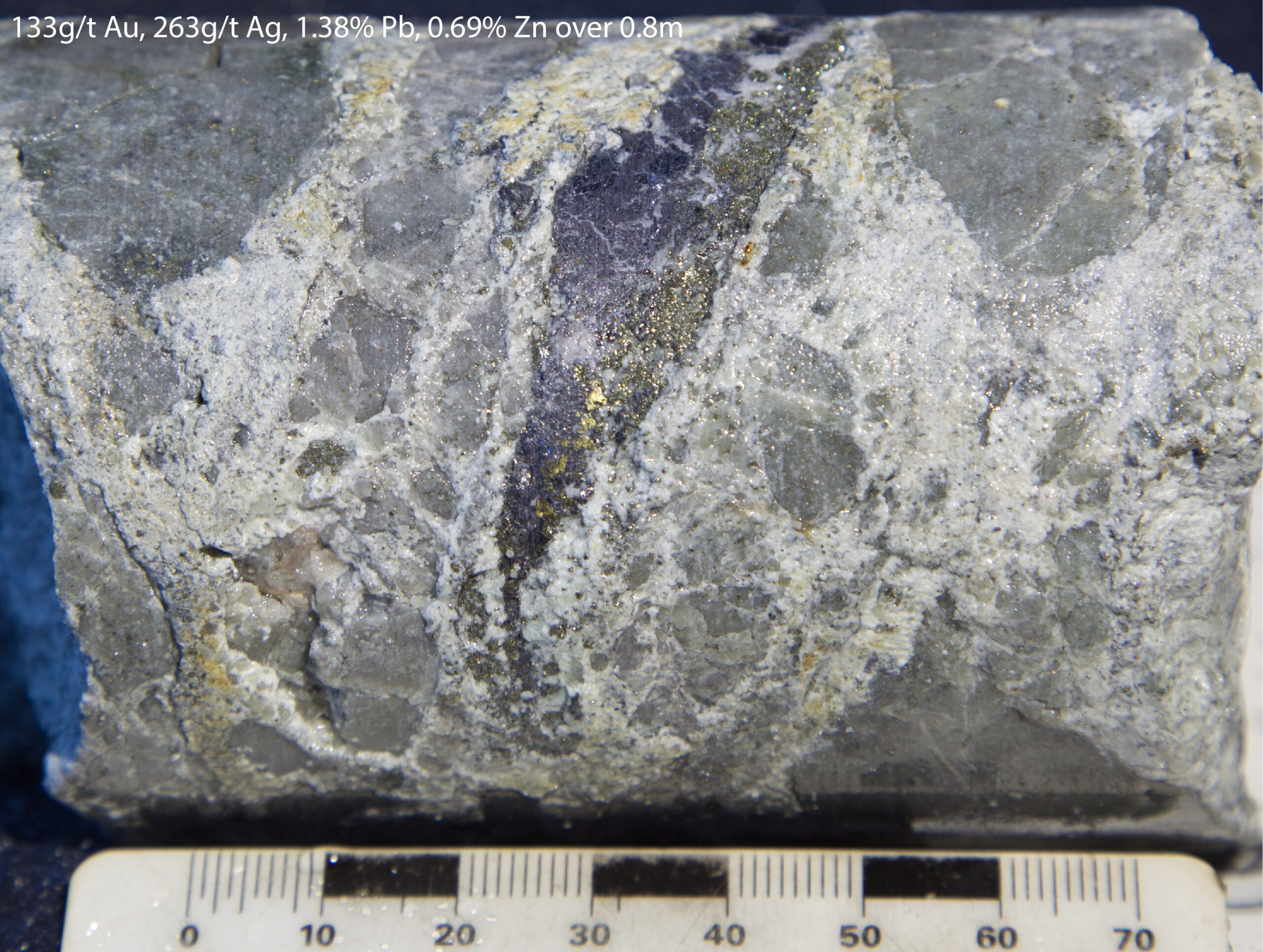
Including | 374.5 | 376.4 | 2.0 | 67.30 | 530.44 | 0.06 | 0.09 | 0.10 |
DDH88-20 | 40.5 | 126.5 | 86.0 | 0.32 |
|
|
|
|
Upper Hank Drill Highlights
Gallery


A new 3D IP inversion product from coupled historical and 2024 lines revealed a 1.6 km long by 0.8 km wide and 850 m deep anomaly (>35 mV/V) – the Lower Hank Porphyry target (see ‘Lower Alteration Zone’ Minfile 104G 107). The geometry of the chargeability body aligns with mapped quartz-sericite-pyrite-chlorite (phyllic and propylitic alteration) on surface. The anomaly is focused at shallow levels and broadens at depth, similar to the Williams chargeability anomaly. At the apex of the anomaly, historical holes intercepted high-grade gold, such as hole HNK-17-001 with 95 g/t Au, 1100 g/t Ag over 0.58 m. Deeper drilled extents that correlate with the uppermost levels of the anomaly intersect porphyry-style broad gold, such as hole HNK-17-006 with 0.44 Au Eq. over 341.7 m. Initial drill holes above this anomaly have only intersected volcanic rocks, and have not yet discovered the key porphyry intrusion that hosts mineralization at Williams. An outcrop to the southeast of the historically drilled area contains stockwork and disseminated style mineralization more typical in porphyry type systems (rock here returned 0.37% Cu, 0.44 g/t Au).

The top of the Williams porphyry deposit is at the same elevation as Au-Ag-Pb-Zn veins along the Lower Hank Trend. The presence of close vertical emplacement levels for epithermal and porphyry systems indicates a process of telescoping. Although historically a high-grade gold target, the new chargeability anomaly at the Lower Hank Porphyry target represents high potential for porphyry discovery due to: 1) the presence of overlap of epithermal gold veins (telescoping) onto porphyry systems at same elevations, 2) the target is on trend and at the same elevation as the Williams deposit, 3) a transition from structurally-controlled gold at shallow levels into broad, disseminated gold at depth typical of porphyry systems, and 4) potential for rapid grade change into mineralizing porphyry intrusions not yet discovered at this anomaly.
Drill Hole | From (m) | To (m) | Interval (m) | Au g/t | Ag g/t | Cu % | Pb % | Zn % |
DDH87-3 | 22.6 | 50.9 | 28.3 | 2.40 |
|
|
|
|
Including | 46.3 | 47.9 | 1.5 | 39.25 | 332.90 |
|
|
|
DDH88-11 | 26.5 | 84.5 | 58.0 | 2.00 |
|
|
|
|
Including | 33.5 | 45.5 | 12.0 | 7.23 |
|
|
|
|
DDH88-14 | 190.0 | 300.0 | 110.0 | 0.43 |
|
|
|
|
DDH88-4 | 137.0 | 146.0 | 9.0 | 6.19 | 1.93 | 0.01 | 0.03 | 0.07 |
And | 280.0 | 323.0 | 43.0 | 3.13 | 31.71 | 0.03 | 0.23 | 0.45 |
Including | 301.4 | 317.0 | 15.6 | 8.18 | 83.05 | 0.06 | 0.61 | 1.15 |
Including | 307.9 | 317.0 | 9.1 | 13.40 | 132.36 | 0.09 | 1.00 | 1.57 |
DDH89-1 | 29.0 | 95.1 | 66.1 | 0.64 |
|
|
|
|
Including | 82.2 | 90.5 | 8.4 | 2.87 |
|
|
|
|
DDH89-10 | 66.0 | 111.9 | 45.9 | 0.48 | 3.93 | 0.01 | 0.02 | 0.11 |
DDH89-11 | 72.3 | 121.6 | 49.3 | 2.17 | 28.93 | 0.02 |
| 0.42 |
Including | 82.0 | 89.4 | 7.4 | 5.77 | 35.19 | 0.02 | 0.01 | 0.44 |
Including | 104.5 | 110.4 | 5.9 | 8.74 | 182.63 | 0.07 |
| 1.29 |
DDH89-3 | 34.0 | 115.6 | 81.6 | 0.47 | 5.27 | 0.01 | 0.03 |
|
DDH89-4 | 20.8 | 84.4 | 63.6 | 1.97 |
|
|
|
|
Including | 53.7 | 70.7 | 17.0 | 6.56 |
|
|
|
|
DDH89-5 | 61.5 | 105.0 | 43.5 | 0.84 | 13.90 | 0.03 | 0.09 | 0.30 |
Including | 94.8 | 98.4 | 3.6 | 7.38 | 124.26 | 0.10 | 0.09 | 1.32 |
DDH89-7 | 10.3 | 101.2 | 90.9 | 0.27 |
|
|
|
|
DDH90-3 | 93.0 | 194.0 | 101.0 | 0.24 | 2.77 | 0.01 | 0.04 | 0.08 |
HNK-17-001 | 207.6 | 245.2 | 37.7 | 1.87 | 23.56 | 0.02 | 0.09 | 0.31 |
Including | 241.1 | 245.2 | 4.1 | 14.97 | 193.85 | 0.10 | 0.77 | 1.97 |
HNK-17-002 | 174.0 | 265.5 | 91.4 | 0.53 | 23.20 | 0.01 | 0.09 | 0.08 |
Including | 223.9 | 224.5 | 0.6 | 54.40 | 3240.00 | 0.04 | 10.60 | 5.59 |
HNK-17-005 | 171.9 | 257.4 | 85.5 | 0.43 | 4.84 | 0.01 | 0.05 | 0.13 |
HNK-17-006 | 74.6 | 416.4 | 341.7 | 0.33 | 3.86 | 0.02 | 0.04 | 0.12 |
Including | 209.1 | 213.2 | 4.1 | 2.18 | 72.12 | 0.12 | 0.19 | 3.32 |
HNK-17-007 | 63.4 | 119.0 | 55.6 | 0.53 | 3.54 | 0.02 | 0.02 | 0.40 |
And | 135.0 | 192.0 | 57.0 | 0.73 | 6.03 | 0.04 | 0.23 | 0.48 |
Including | 185.3 | 185.9 | 0.6 | 45.10 | 234.00 | 1.25 | 1.88 | 4.41 |
HNK-17-008 | 52.7 | 113.0 | 60.3 | 2.12 | 6.91 | 0.02 | 0.11 | 0.45 |
Including | 111.1 | 111.9 | 0.8 | 133.00 | 263.00 | 0.07 | 1.38 | 0.69 |
HNK-17-009 | 127.0 | 195.2 | 68.2 | 2.40 | 17.97 | 0.04 | 0.00 | 0.10 |
Including | 133.7 | 158.6 | 24.8 | 5.59 | 45.94 | 0.09 | 0.00 | 0.10 |
HNK-17-010 | 4.8 | 110.0 | 105.2 | 0.36 | 1.87 | 0.02 | 0.03 | 0.21 |
HNK-17-012 | 5.4 | 160.6 | 155.3 | 0.20 | 1.08 | 0.02 | 0.01 | 0.13 |
HNK-17-014 | 121.0 | 183.0 | 62.0 | 0.28 | 2.19 | 0.02 | 0.03 | 0.28 |
HNK-18-011 | 439.7 | 483.3 | 43.6 | 0.39 | 3.91 | 0.01 | 0.01 | 0.12 |
DDH87-7 | 9.8 | 119.5 | 109.7 | 0.36 |
|
|
|
|
DDH87-8 | 5.2 | 129.0 | 123.8 | 0.34 |
|
|
|
|
DDH88-16 | 25.5 | 100.0 | 74.5 | 0.43 |
|
|
|
|
DDH88-17 | 7.5 | 143.0 | 135.5 | 0.16 |
|
|
|
|
Lower Hank Drill Highlights
Gallery

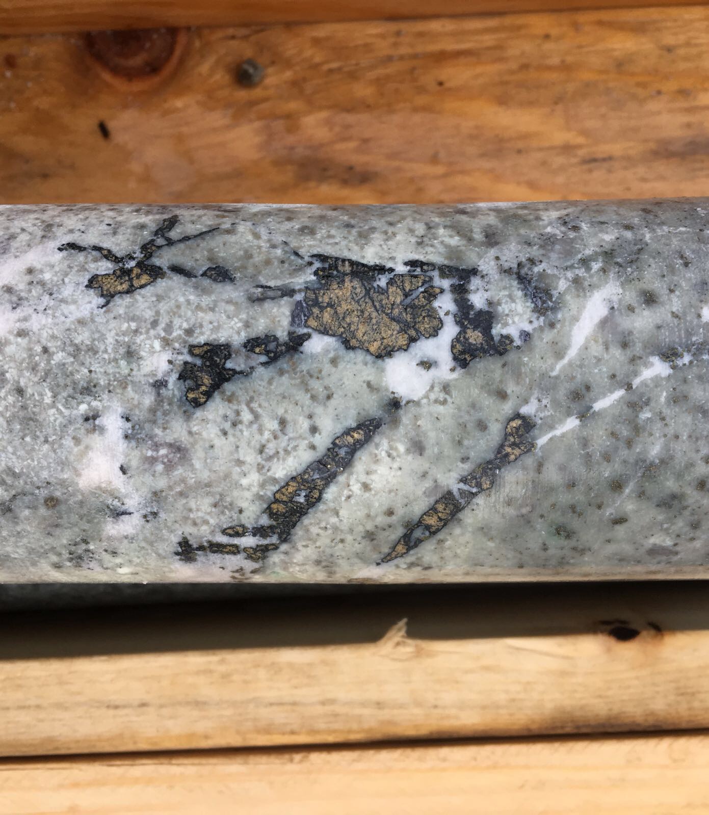


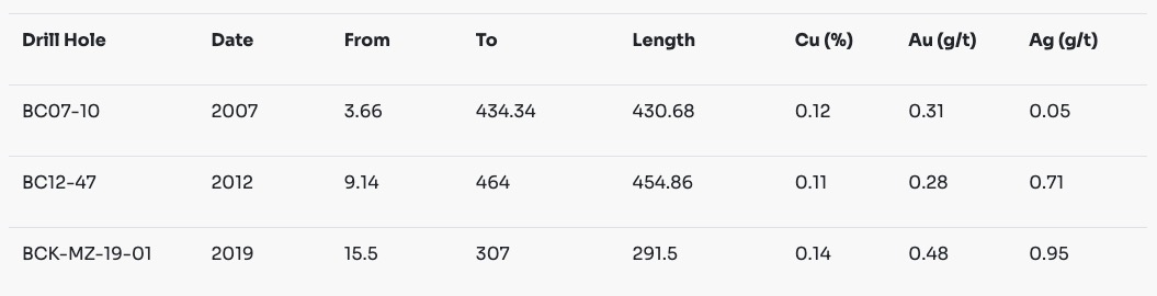
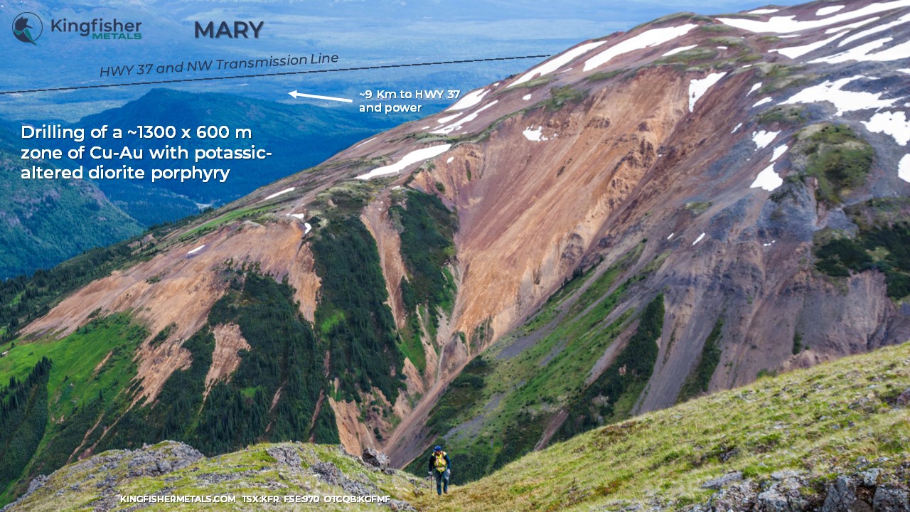
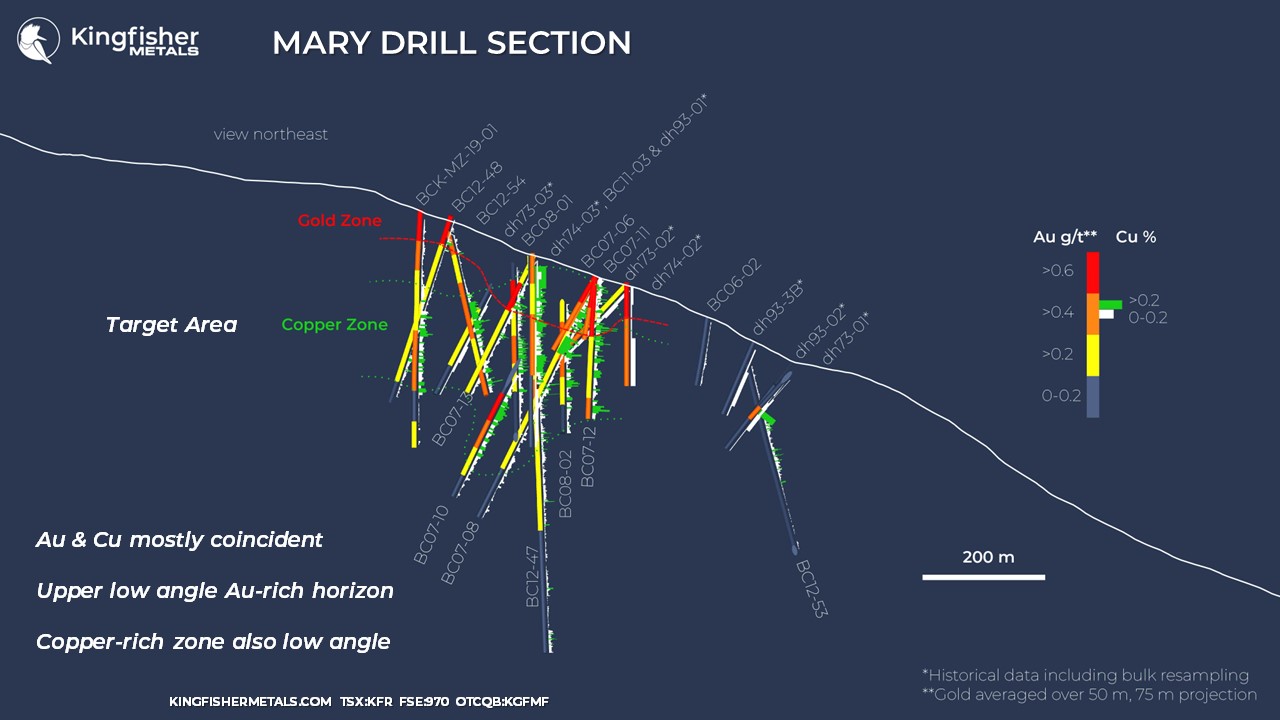
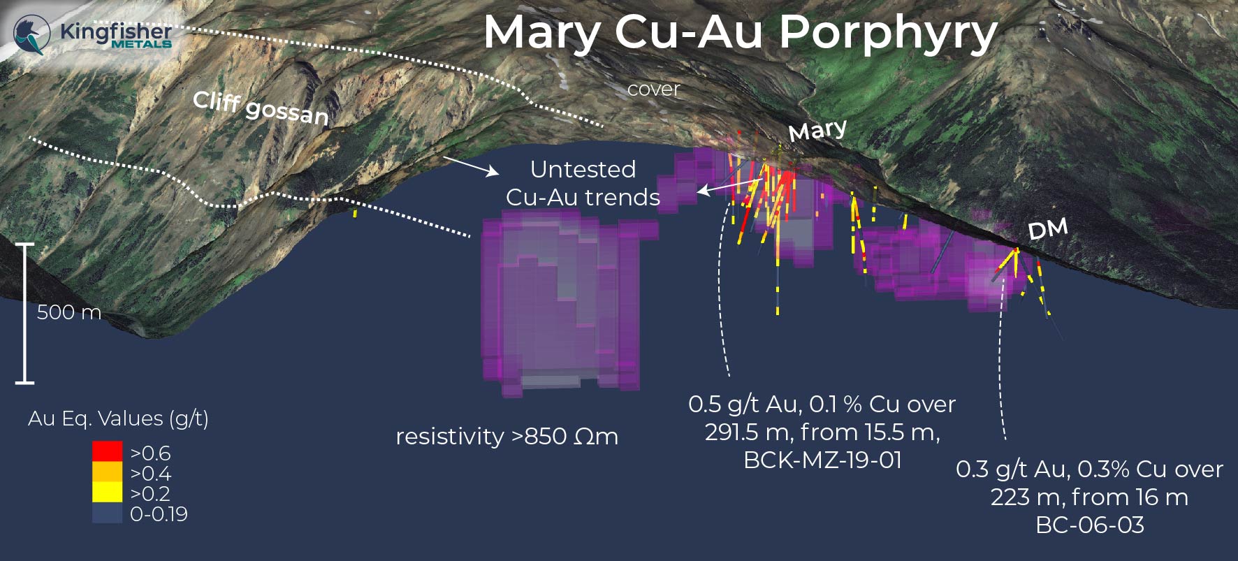
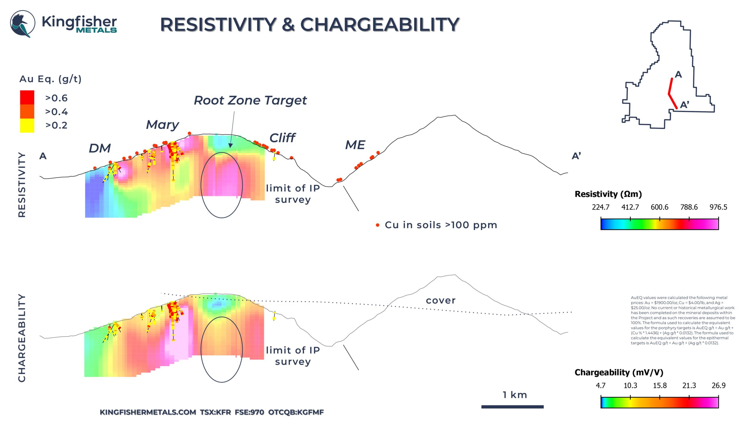
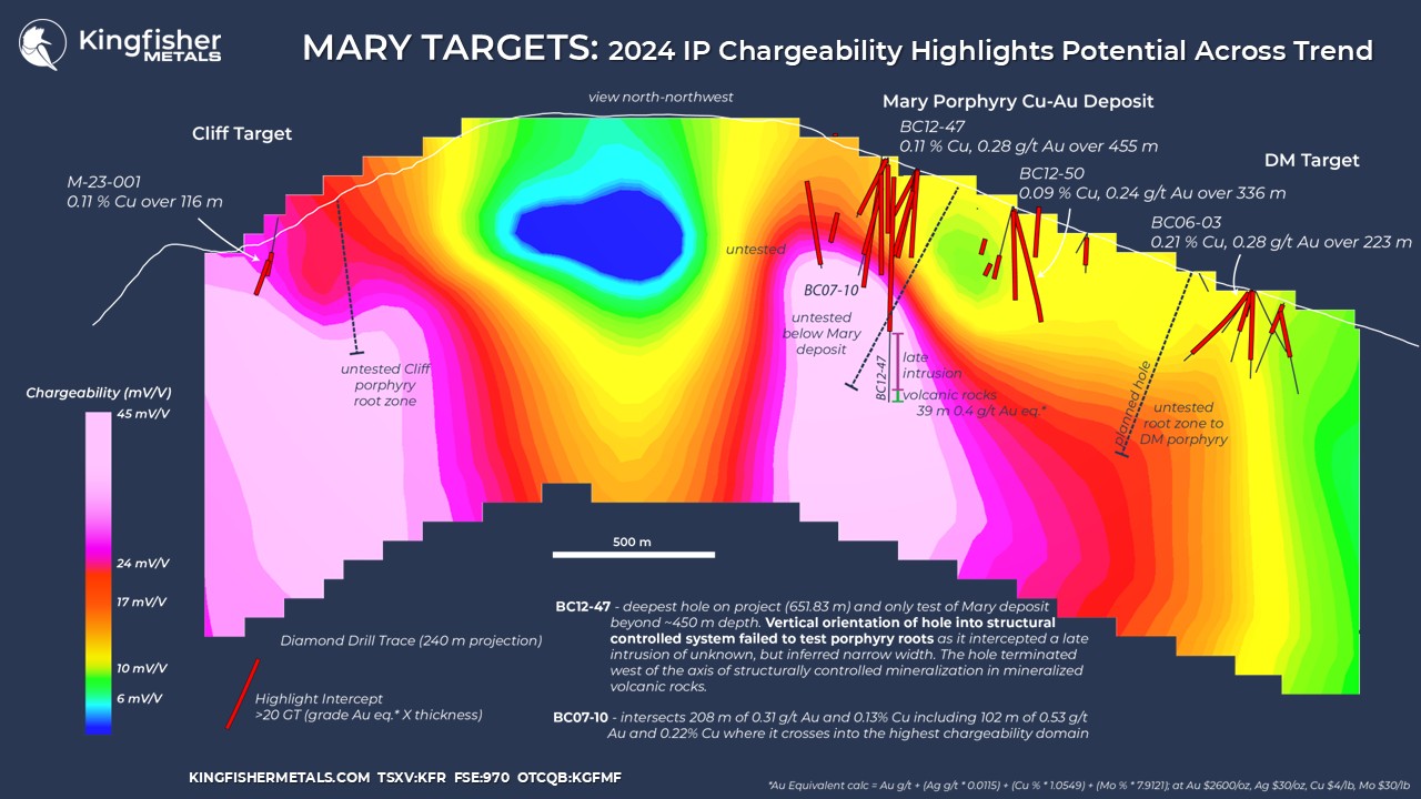
The drill footprint of the Mary area spans 3 km focused along a north-northeast trend defined by the Cliff target, Mary deposit (Minfile 104G 018) and the DM porphyry. Drilling at Mary began in the 1970s from surface mineralization and the first modern 2D induced-polarization survey was completed in 2012 with NWW-trending orientation. Most holes at Mary test relatively shallow depths (300-400 m), but the first deep hole was planned following the first IP survey to drill toward the highest chargeability value that had been defined to date. This hole, BC12-47, intercepted 455 m of 0.11% Cu and 0.28 g/t Au until it cut a late, relatively unaltered monzonite dyke and terminated in volcanic rocks with 39 m of 0.4 g/t Au Eq.
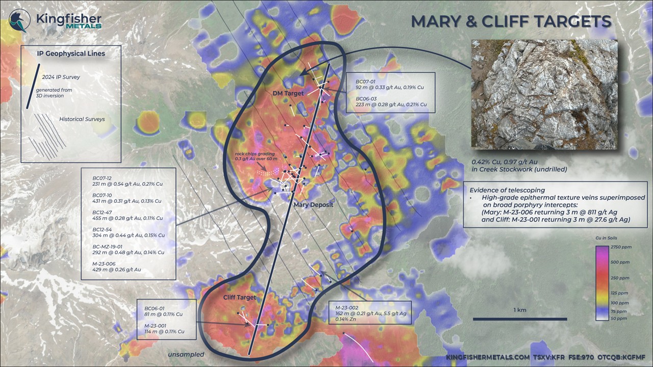
A largely untested subvertical chargeability anomaly below Mary swells from ~350 m width near surface to 750 m width at depth (>25 mV/V). The vertical orientation of hole BC12-47 into a structurally controlled system failed to test the porphyry intrusions at depth and failed to cross peak chargeability values. The late intrusion intercepted in the hole is interpreted to have a steep geometry (narrow width) and is not the causative intrusion. The hole failed to reach the core of the chargeability anomaly, located to the south, and did not intercept source intrusions below Mary and failed to explain the source of the deep chargeability anomaly.
The chargeability anomaly below Mary is interpreted as a significant untested porphyry target. At the Williams deposit, grade is closely tied to both chargeability and to the location of structurally focused porphyry intrusions. The presence of significant grade in volcanic rocks at depth is interpreted to indicate proximity to the porphyry intrusion body below Mary. Hole BC07-10 provides evidence for such a porphyry target, where 102 m of 0.53 g/t Au and 0.22% Cu in a porphyry host are intersected in peak chargeability values at depth.
Along trend ~850 m from Mary, significant lateral and vertical expansion potential at the DM porphyry is also indicated. The DM porphyry is characterized by higher Cu:Au ratios compared to Mary, such as 0.21% Cu and 0.28 g/t Au over 223 m from surface. The chargeability anomaly appears to plunge from the DM porphyry at surface toward Mary, to
the SW. Based on the chargeability anomaly, the DM porphyry is interpreted to have significant vertical extent beyond the ~230 m drilled extent. Off the IP section line, the presence of stockwork with 0.42% Cu and 0.97 g/t Au also indicates lateral, or width, potential.
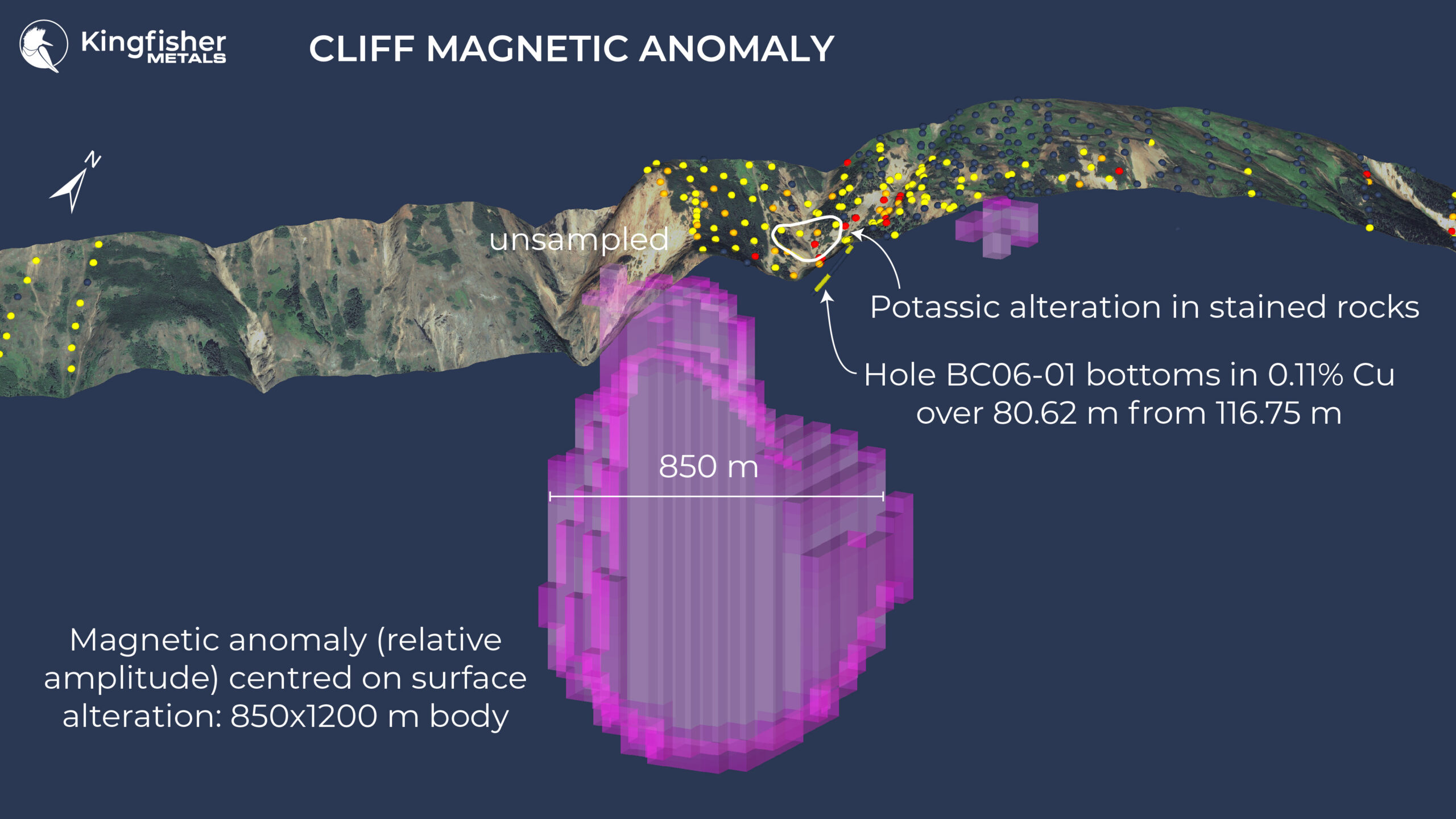
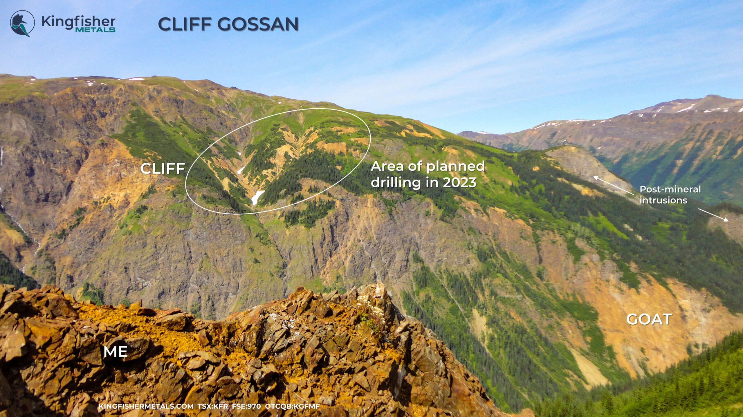
The Cliff porphyry lies on the flanks of a new chargeability anomaly 700 m wide and 1 km deep ( > 25 mV/V) identified in the 2024 survey, similar in geometry and calibre to the anomaly centered on the Mary deposit. Alteration patterns, intrusive geometry and quartz stockwork abundance trends indicate a projection of the porphyry system into the slope, to the NE. Only three holes have tested the Cliff porphyry, returning up to 0.11% Cu, 66 ppm Mo over 116. The geometry of the chargeability anomaly indicates a large untested body to the NE, and the presence of high relative Mo, and low relative Au in these initial holes is consistent with the interpretation that the drilled domain is lateral to and flanking a porphyry target into the slope.
Drill Hole | From (m) | To (m) | Interval (m) | Au g/t | Cu % | Ag g/t | Target Area |
BC07-05B | 15.6 | 99.2 | 83.6 | 0.19 | 0.08 | 0.25 | Mary |
BC07-06 | 0.0 | 139.8 | 139.8 | 0.60 | 0.23 | 0.45 | Mary |
Including | 108.8 | 138.1 | 29.3 | 0.72 | 0.40 | 0.77 | Mary |
BC07-07 | 18.7 | 87.0 | 68.3 | 0.27 | 0.18 | 2.83 | Mary |
BC07-08 | 0.0 | 381.0 | 378.6 | 0.33 | 0.12 | 1.09 | Mary |
Including | 51.2 | 94.5 | 43.3 | 0.63 | 0.23 | 0.52 | Mary |
BC07-09 | 84.4 | 175.8 | 91.4 | 0.20 | 0.05 | 0.31 | Mary |
BC07-10 | 3.7 | 434.3 | 430.7 | 0.31 | 0.12 | 0.28 | Mary |
Including | 239.9 | 364.9 | 125.0 | 0.53 | 0.22 | 0.31 | Mary |
BC07-11 | 12.2 | 105.8 | 93.6 | 0.61 | 0.15 | 0.41 | Mary |
BC07-12 | 3.4 | 234.4 | 231.0 | 0.53 | 0.21 | 0.36 | Mary |
Including | 55.5 | 113.4 | 57.9 | 0.69 | 0.27 | 0.32 | Mary |
BC07-13 | 6.1 | 254.8 | 248.7 | 0.35 | 0.11 | 0.75 | Mary |
BC08-01 | 33.0 | 298.0 | 265.0 | 0.41 | 0.16 | 2.51 | Mary |
Including | 159.0 | 220.0 | 61.0 | 0.49 | 0.26 | 1.42 | Mary |
BC08-02 | 78.7 | 282.9 | 195.1 | 0.44 | 0.18 | 0.96 | Mary |
BC11-02 | 16.8 | 170.0 | 153.2 | 0.23 | 0.10 | 0.98 | Mary |
BC11-03 | 21.0 | 201.3 | 180.3 | 0.35 | 0.14 | 0.63 | Mary |
BC11-04 | 3.0 | 137.2 | 134.2 | 0.17 | 0.05 | 0.44 | Mary |
BC12-47 | 9.1 | 464.0 | 454.9 | 0.28 | 0.11 | 0.71 | Mary |
Including | 190.6 | 240.5 | 49.9 | 0.60 | 0.24 | 1.24 | Mary |
BC12-48 | 4.6 | 298.2 | 293.6 | 0.40 | 0.08 | 0.81 | Mary |
Including | 7.5 | 60.7 | 53.2 | 0.77 | 0.09 | 1.16 | Mary |
BC12-50 | 10.7 | 347.0 | 336.3 | 0.24 | 0.09 | 0.57 | Mary |
Including | 32.9 | 139.4 | 106.5 | 0.33 | 0.16 | 0.71 | Mary |
BC12-51 | 8.2 | 188.9 | 180.7 | 0.18 | 0.11 | 1.12 | Mary |
BC12-53 | 150.8 | 266.5 | 115.7 | 0.19 | 0.12 | 0.67 | Mary |
BC12-54 | 2.9 | 307.0 | 304.2 | 0.44 | 0.15 | 1.01 | Mary |
Including | 122.0 | 307.0 | 185.0 | 0.44 | 0.21 | 1.23 | Mary |
BC12-56 | 13.7 | 249.9 | 236.2 | 0.19 | 0.08 | 0.44 | Mary |
BCK-MZ-19-01 | 15.5 | 307.0 | 291.5 | 0.48 | 0.14 | 0.95 | Mary |
dh74-03 | 78.1 | 214.3 | 135.3 | 0.55 | 0.23 | 1.20 | Mary |
dh93-01 | 48.8 | 258.2 | 209.4 | 0.39 | 0.16 |
| Mary |
BC06-01 | 116.8 | 197.4 | 80.6 | 0.05 | 0.11 | 0.66 | Cliff |
M-23-001 | 264.9 | 381.0 | 116.1 | 0.04 | 0.11 | 1.28 | Cliff |
BC06-03 | 16.0 | 239.3 | 223.3 | 0.28 | 0.21 | 2.15 | DM |
Including | 104.0 | 139.0 | 35.0 | 0.60 | 0.40 | 4.66 | DM |
BC07-01 | 7.6 | 103.3 | 95.7 | 0.32 | 0.18 | 1.20 | DM |
Including | 60.3 | 97.5 | 37.3 | 0.49 | 0.28 | 2.08 | DM |
BC07-03 | 45.4 | 102.7 | 57.3 | 0.29 | 0.19 | 3.46 | DM |
BC12-49 | 8.1 | 134.9 | 126.8 | 0.28 | 0.18 | 2.09 | DM |
Including | 8.1 | 65.2 | 57.1 | 0.44 | 0.28 | 3.27 | DM |
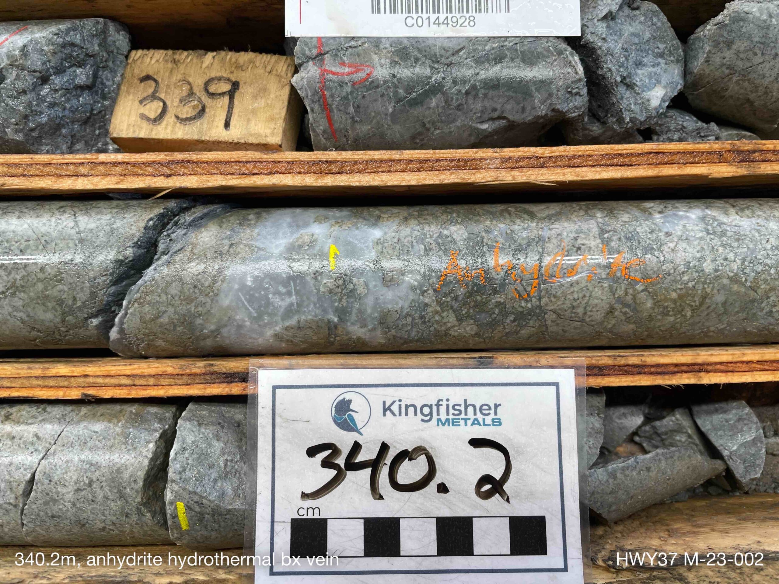
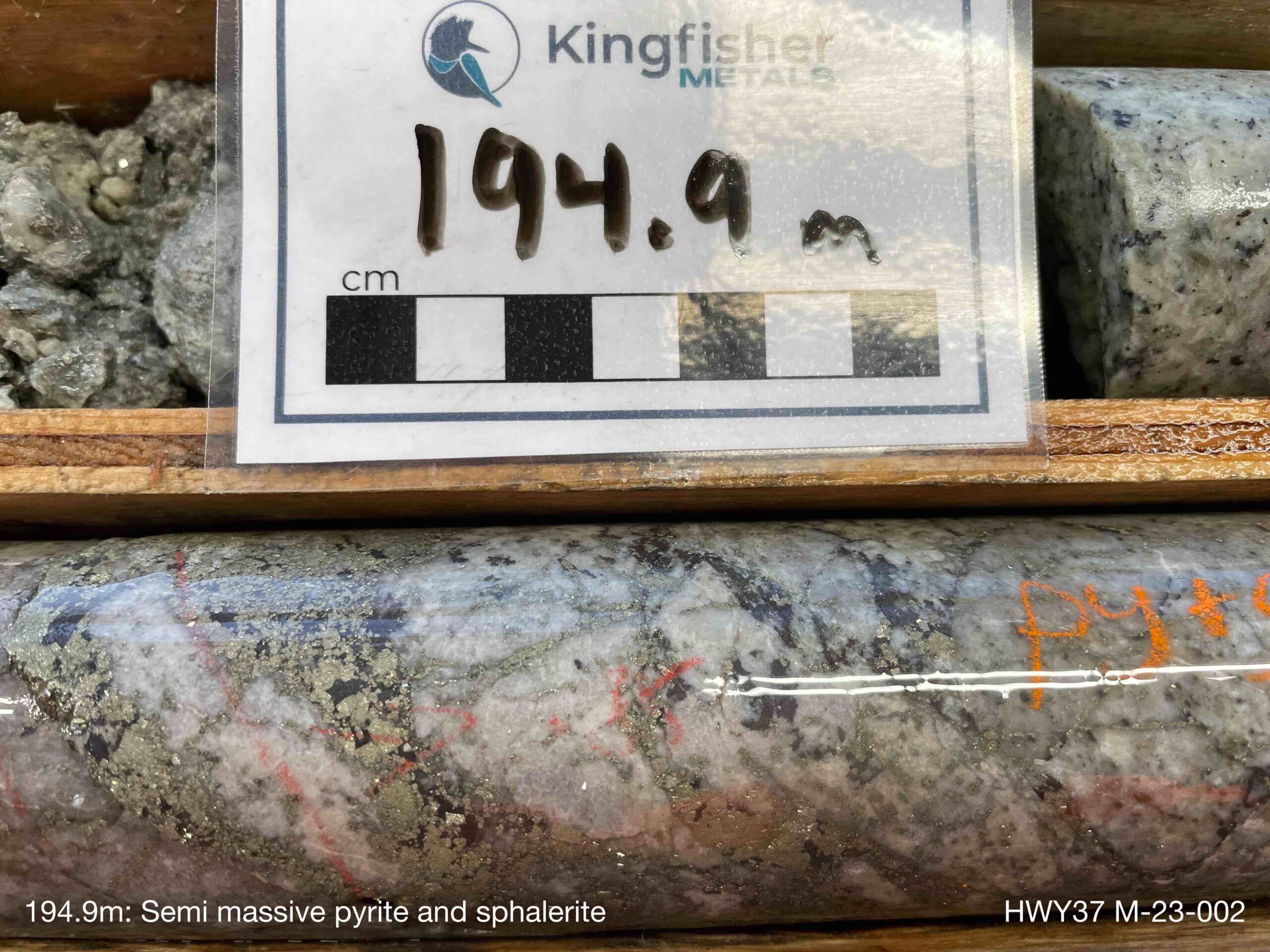
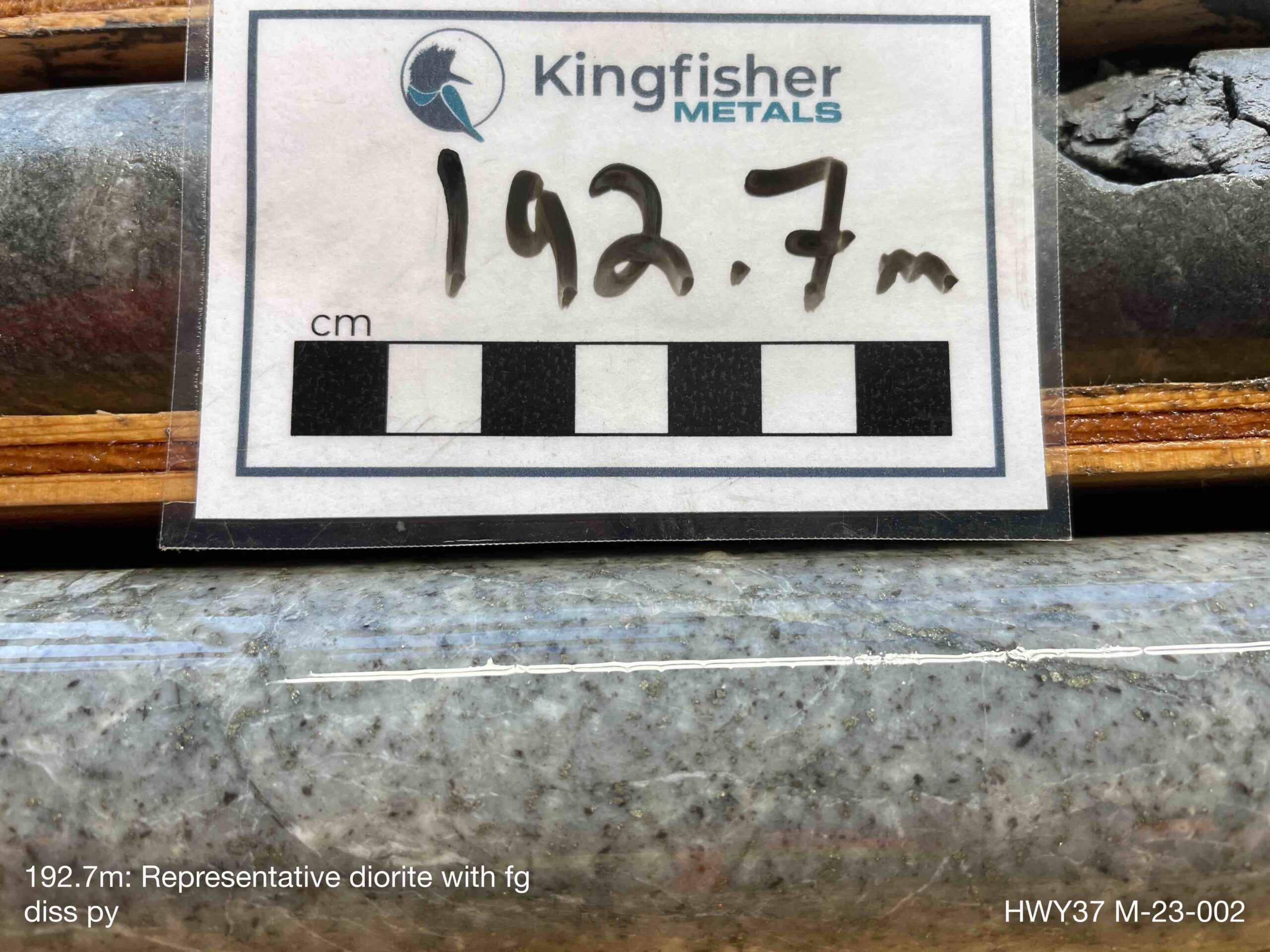
M-23-002 | 79.3 | 241.0 | 161.8 | 0.21 | 0.01 | 5.51 | Mary |
M-23-006 | 9.0 | 438.0 | 429.0 | 0.26 | 0.04 | 6.13 | Mary |
Mary, Cliff, and DM Drill Highlights
Gallery


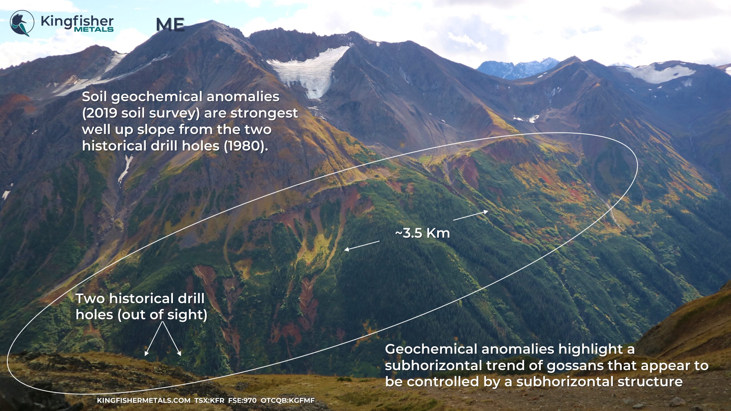
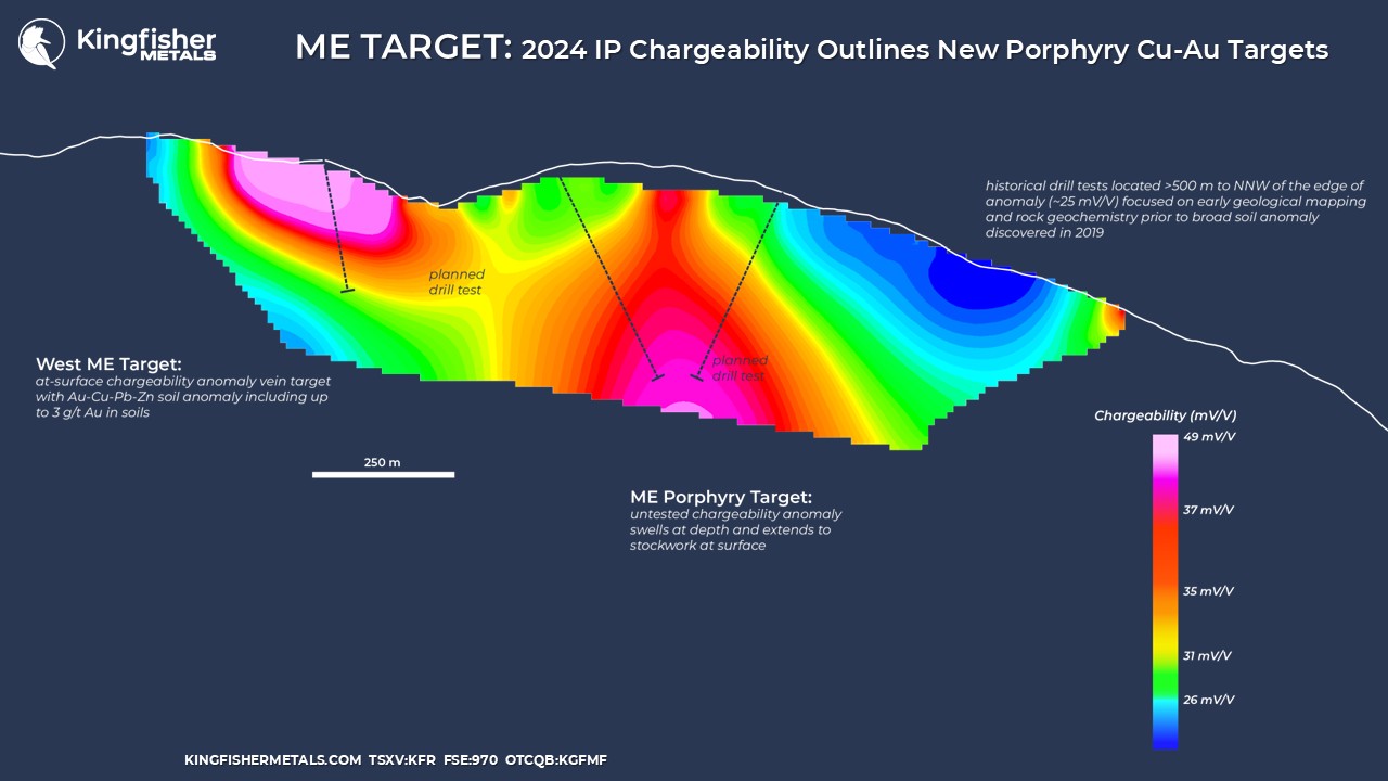
The ME porphyry Cu-Au target (Minfile 104G 042) is situated at the south end of the Mary trend where from-surface, untested chargeability anomalies were identified in a 2024 survey. The area is host to NE-striking porphyry stocks that trend towards the prominent Goat gossan. Mineralization in the area is related to porphyry quartz stockwork with chalcopyrite-pyrite-molybdenite and increasing concentrations of galena, associated with a flanking porphyry position, to the north and northeast away from the IP chargeability anomalies defined in 2024. The ME Target is host to an open-ended soil geochemical anomaly (Cu-Au-Ag-Mo-Pb) that stretches over 3.5 km with grades up to 2900 ppm Cu, 3210 ppb Au, 36,500 ppb Ag, and 750 ppm Mo.
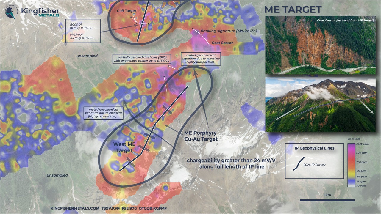
Two historical drill holes were completed downslope of the 2024 IP anomalies in 1980. Incomplete assays are available for these holes with reports of grades up to 0.16% Cu. These drill holes were completed prior to the 2019 geochemical soil survey that outlined the broad anomaly.
Mapping in 2024 indicates that these drill holes were misoriented, were located laterally far away from the interpreted core, and are too far downslope of the mapped stockwork on surface. Consistent with this, historical drill logs identified widespread sodic alteration, common in deeper flanking positions to Cu-Au porphyry systems. These holes were located over 500 m from the chargeability targets identified in 2024.
Gallery


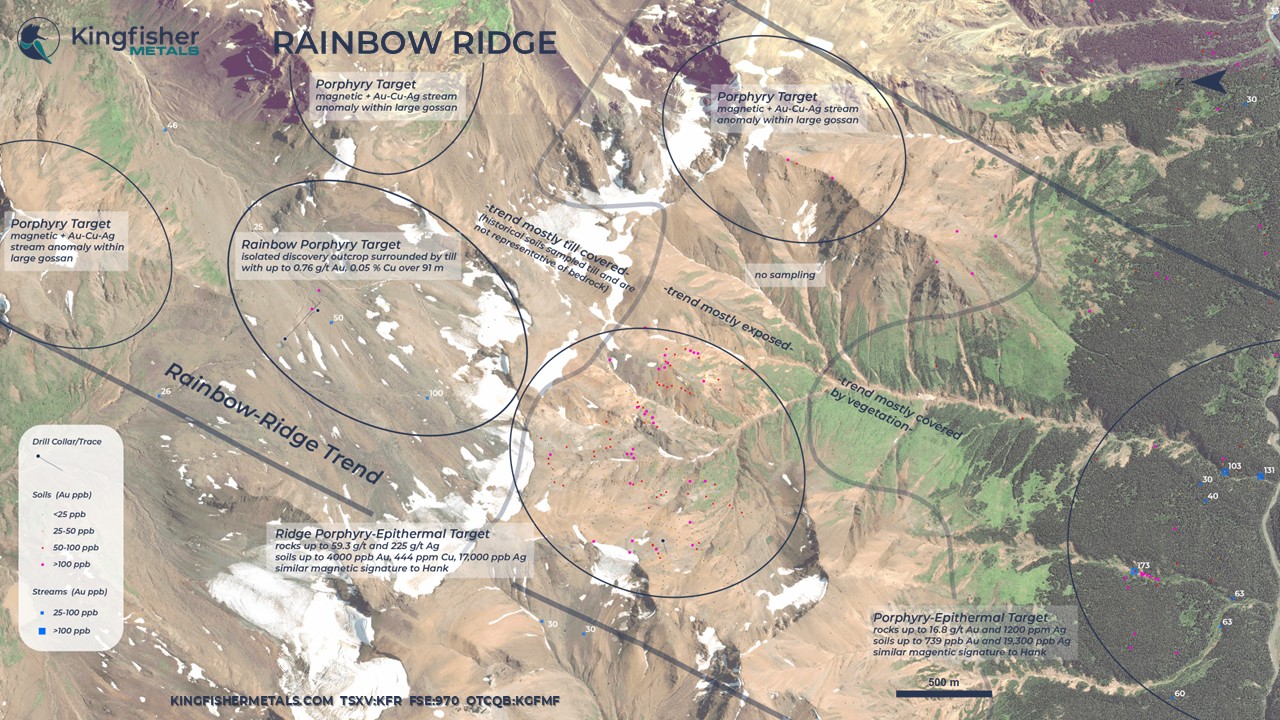
The gold-rich quartz breccia and stockwork were discovered at Rainbow, or ‘Rainbow North,’ (Minfile 104G 255) in the early 2000s. The first-ever drill hole intersected 0.76 g/t Au over 91.4 m from surface in 2011. Two follow-up drill holes failed to intersect similar mineralization. The outcrop showing is surrounded by broad gossan and anomalous Cu-Au geochemistry.
This early-stage discovery has a drill footprint of only ~250 x 50 m. Future drill targets at Rainbow require ground geophysical surveys to target below a widespread mask of glacial till cover rock. Mapping in 2025 identified grade on surface associated with a magnetite-cement breccia. Magnetite can be easy visualized by a ground magnetic survey.
Drill Hole | From (m) | To (m) | Interval (m) | Au g/t | Cu % | Ag g/t |
RN11-01 | 3.1 | 94.5 | 91.4 | 0.76 | 0.05 | 1.99 |
Rainbow Ridge Drill Highlights
Gallery

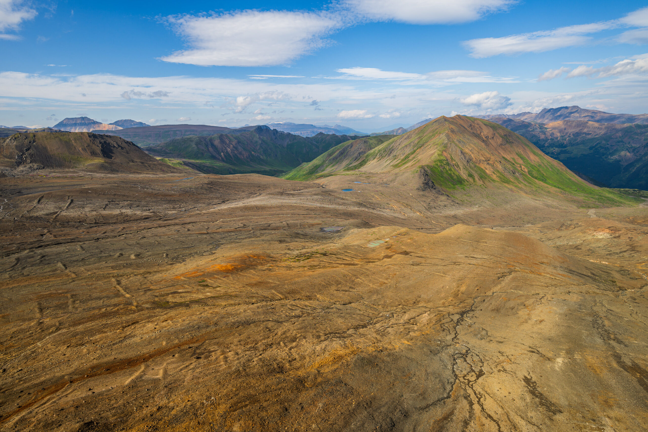
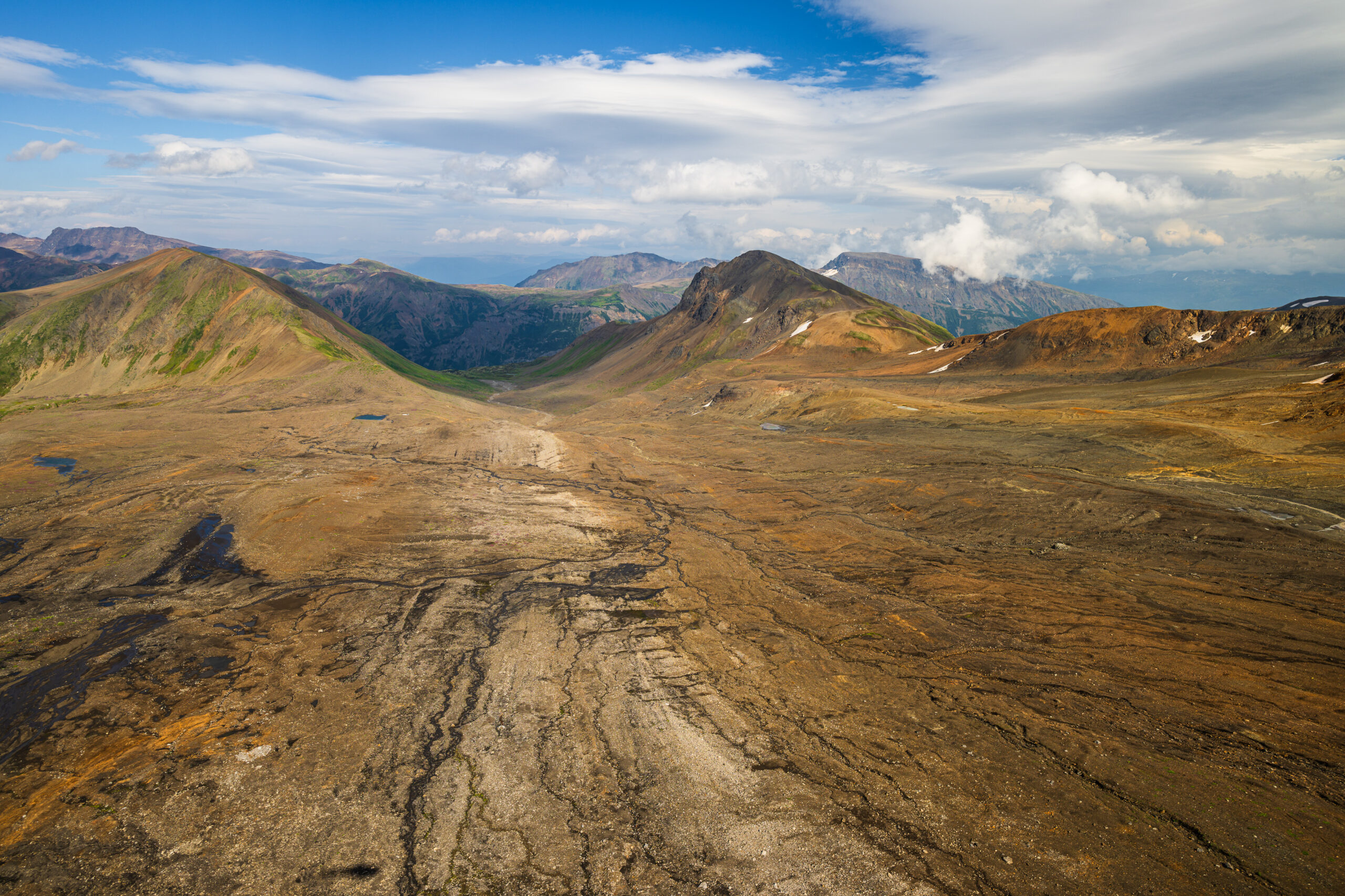


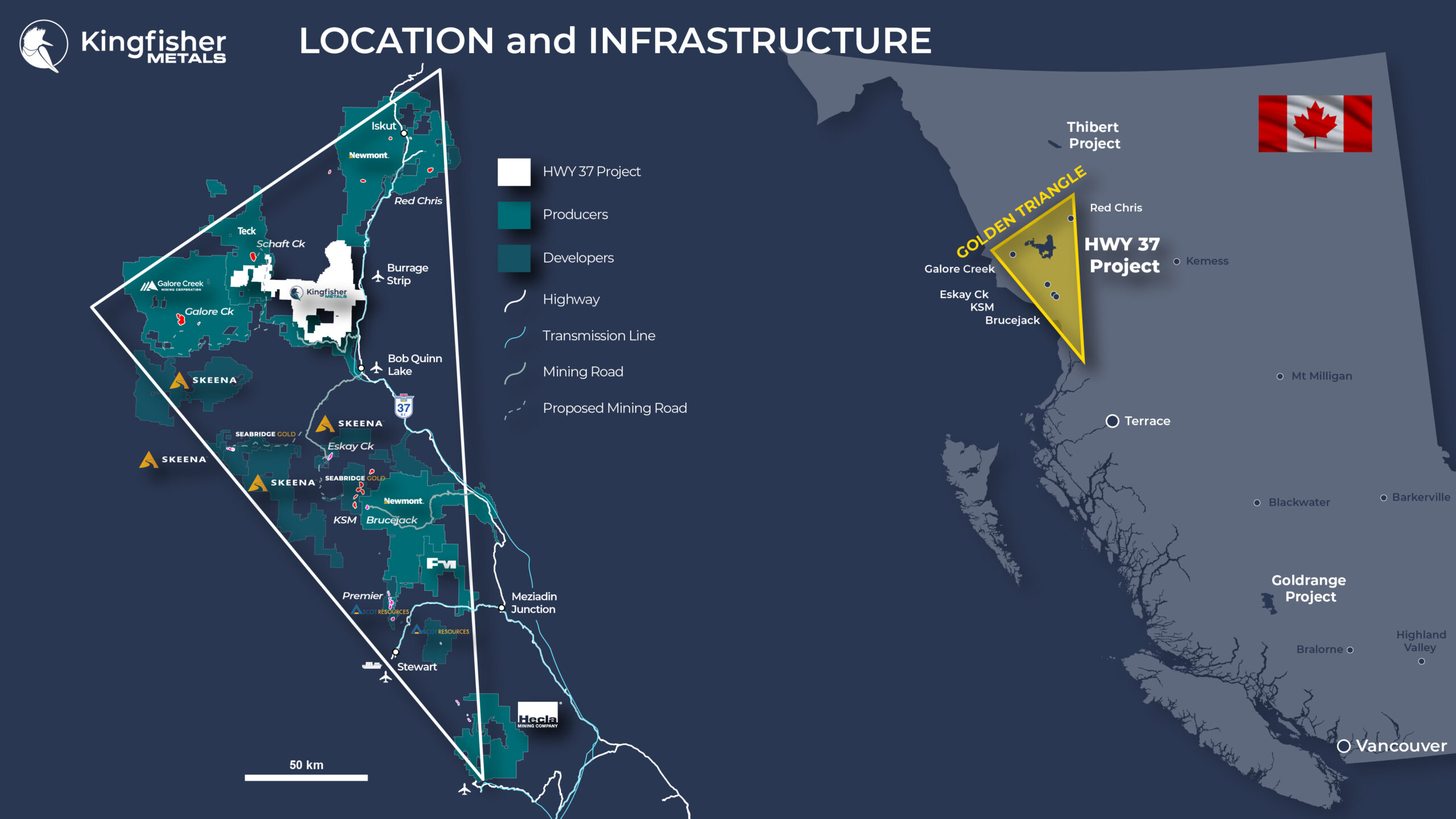
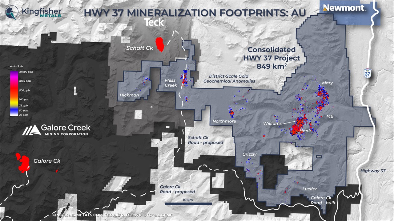
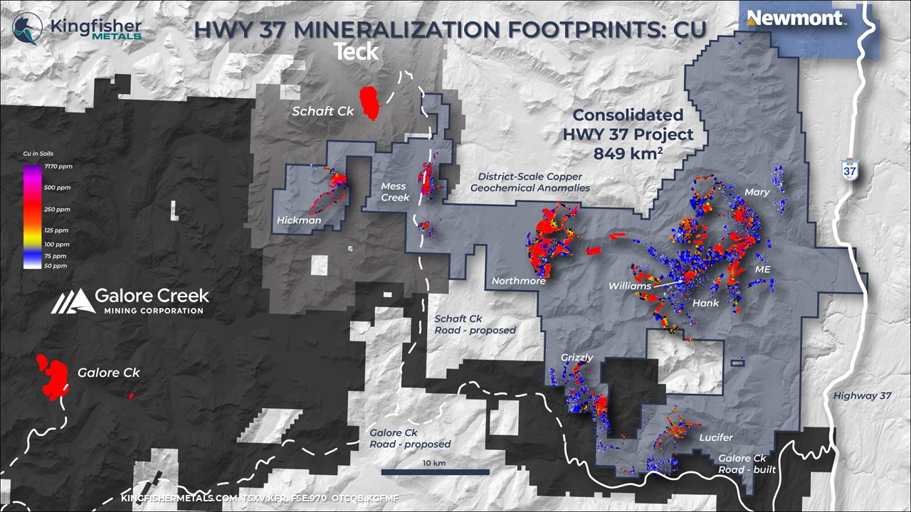
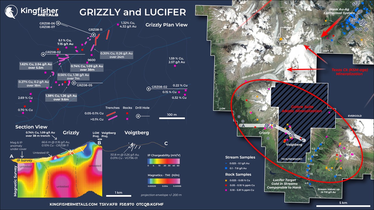
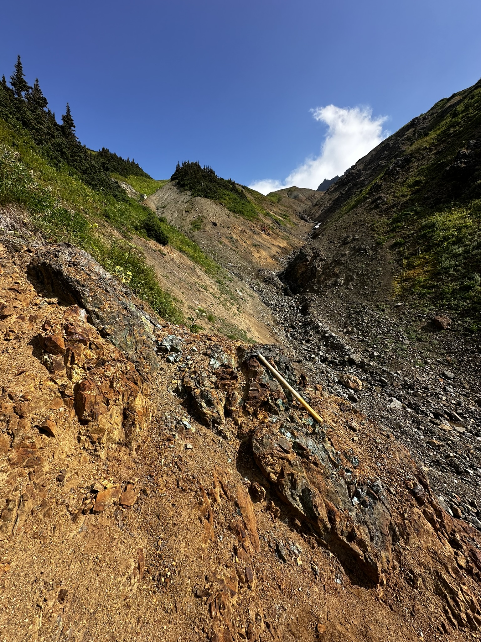
The Grizzly target (Minfile 104G 079) is a silica-undersaturated alkalic Cu-Au porphyry with a comparable setting to Galore Creek. Grizzly is situated at the southern extent of the HWY 37 Project in what was formerly known as the LGM tenures. Grizzly is adjacent to the Voigtberg Project held by Galore Creek Mining Corp (Teck/Newmont). Southeast of Grizzly lies the Lucifer Target area that covers a broad area of highly anomalous gold in streams and soils.
The Grizzly target is centered on a surface trench of 0.74% Cu and 1.09 g/t Au over 38 m and lies within a 1 km by 1 km Cu-Au-Ag-Mo soil geochemical anomaly that grades up to 2916 ppm Cu, 1100 ppb Au, 5.4 ppm Ag, and 160 ppm Mo. Rock sampling results up to 5.91% Cu and 13 g/t Au at Grizzly were the focus of a small drill program in 2008, with 1442.9 m of diamond drilling.
The small program failed to identify the geometry of the porphyry intrusion and drilled exclusively along an east-west azimuth. The NNE axis of mineralization in moderately S-dipping gully defined by rocks was not crossed by the 2008 drill holes. Anomalous intercepts from 2008 include 0.16 g/t Au and 0.10% Cu over 66.6 m (hole GRZ08-11). The first-ever 3D modelling was completed by Kingfisher in 2024, and it highlighted porphyry mineralization outlined by historical trenching occurs as a ~150 m wide panel that dips moderately to the south on the shoulder of a large magnetic anomaly.
Geophysical surveys followed-up on 2008 drilling that identified a chargeability and magnetic anomaly directly below the Grizzly trench showing. The strongest chargeability anomaly remains untested and lies downslope from the Grizzly showing in a region where monzonite to syenite porphyry is mapped on surface. Three large untested magnetic anomalies were identified at depth below the Grizzly showing, the most westerly coincides with a moderate shallow chargeability anomaly.
The Grizzly showing appears to be a high-level, Galore Creek-type setting with several untested geophysical anomalies and excellent trench results that have not been crossed by drilling. The LGM/Voigtberg, Galore Creek, and Newmont Lake projects represent the only three areas in the Golden Triangle where ~210-208 Ma silica-undersaturated, alkalic magmatic-volcanic complexes are identified. These rare and Cu-Au-rich systems are marked by the presence of pseudoleucite in both the intrusions and in the overlying volcanic rocks.
Although many Galore Creek suite intrusions are identified in the region, only three reflect full vertical preservation that includes the pseudoleucite-bearing volcanic carapace. Galore Creek is the most advanced of these projects with a measured and indicated resource of 1,197 Mt at 0.46% Cu and 0.25 g/t Au*, and the Newmont Lake Project is host to the Burgundy Ridge drill delineated Cu-Au porphyry deposit. The LGM/Voigtberg region represents rare exposure to a Galore Creek-type system, and the only magmatic-volcanic complex where a deposit has not yet been delineated.
*The Company notes that mineralization on nearby projects is not indicative of mineralization on the HWY 37 Project
HoleID | From (m) | To (m) | Interval (m) | Au g/t | Cu % | Ag g/t |
GRZ08-11 | 70.7 | 140.4 | 69.7 | 0.10 | 0.35 | 0.15 |
Grizzly Drill Highlights
Gallery
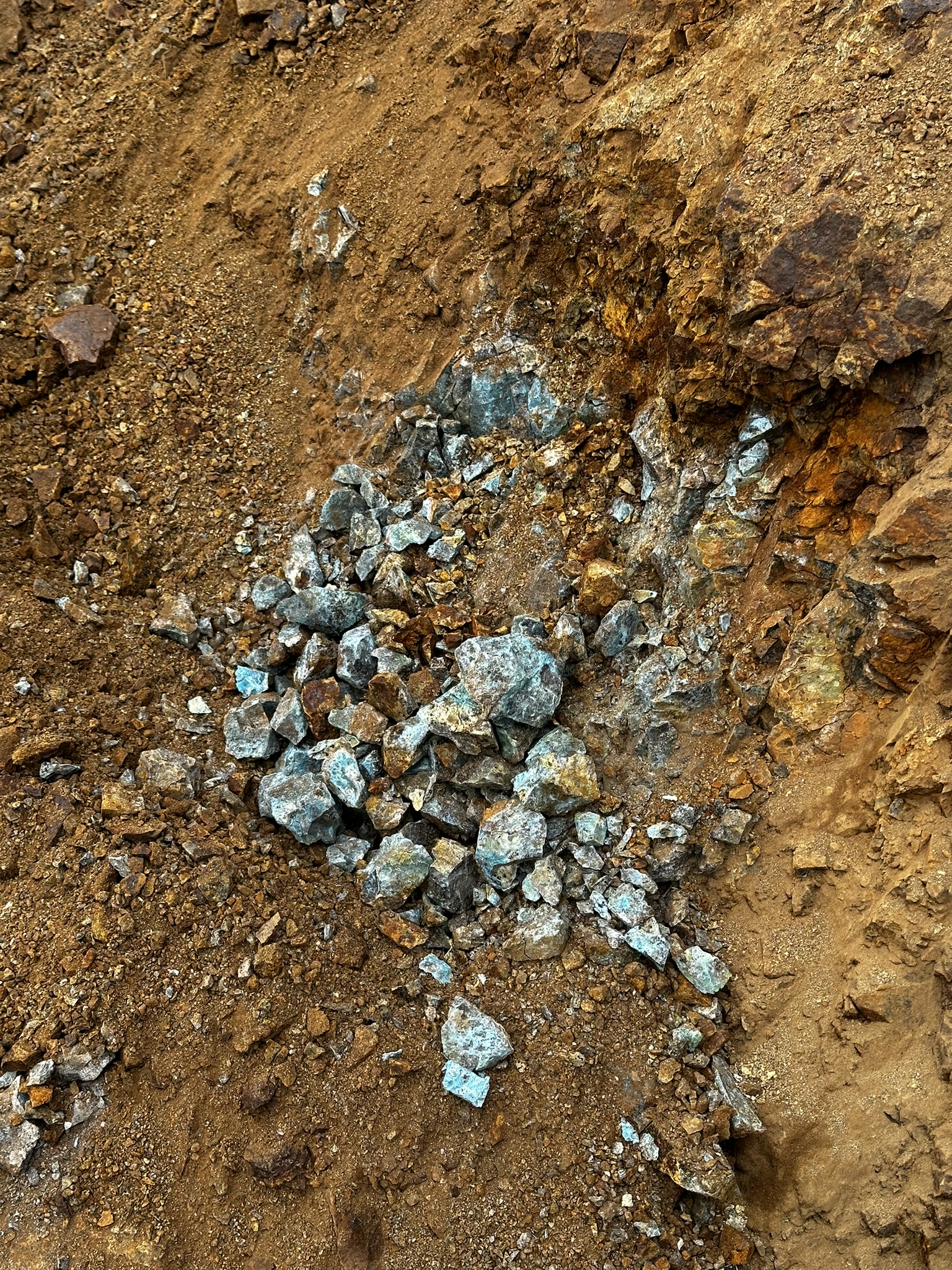
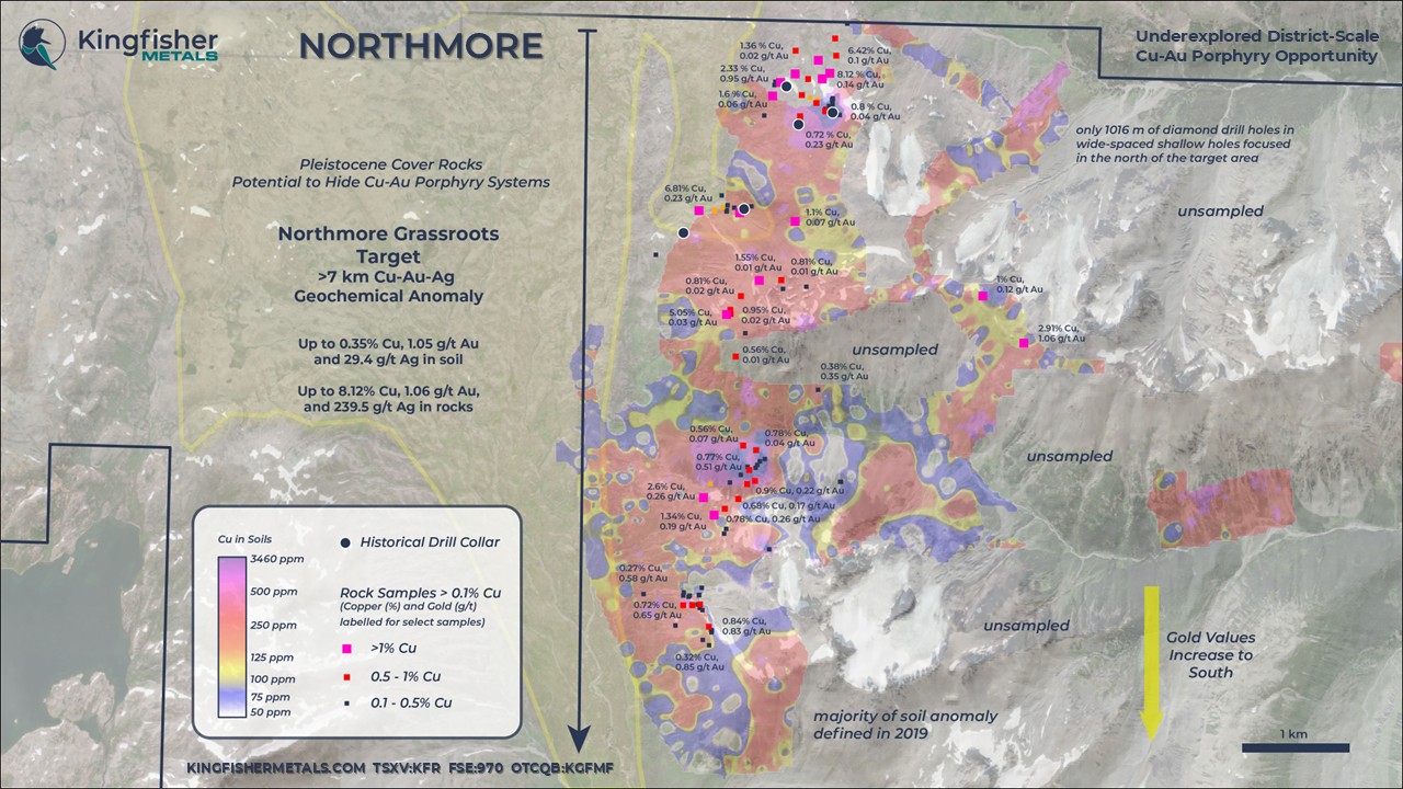
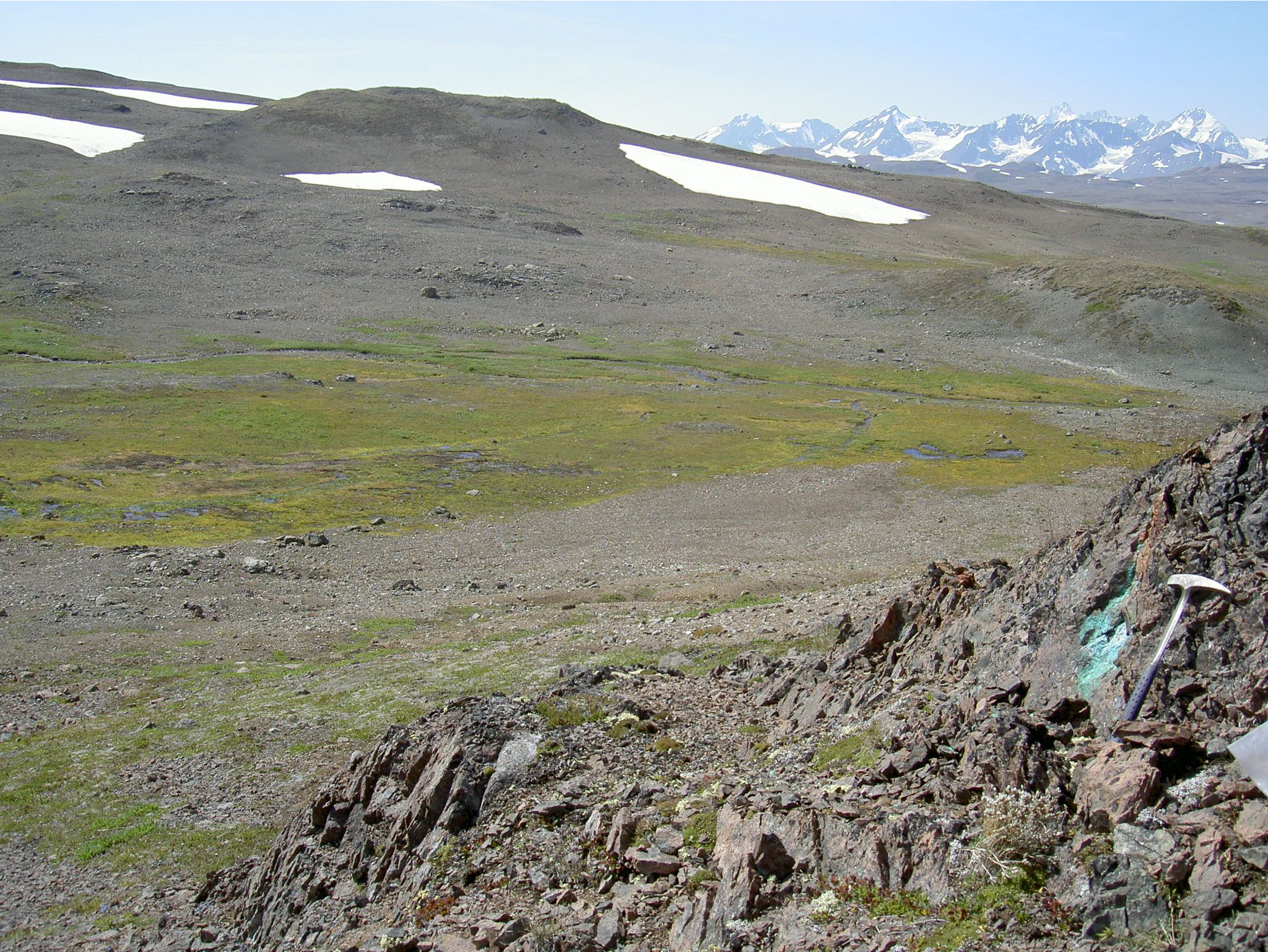
The Northmore grassroots target area (Minfile 104G 259) includes a soil anomaly that extends 7 km N-S and has a width of 1.5-2.5 km E-W with several sampling gaps in steep gossan slopes. The broad Cu-Au-Ag-Mo multi-element anomaly reflects a region with a mix of outcrop and vegetative cover. Rock samples from the anomaly include up to 8.12% Cu and 1.06 g/t Au. Five shallow widely spaced drill holes totalling 1016 m tested the anomaly focused at the north. Drilling returned anomalous copper grades (~400-800 ppm Cu) over widths of 25 to 100 m.
A historical 11 line-km induced polarization-resistivity survey at the northern anomaly, completed in 1991, showed chargeability increasing in the eastern portion of the grid. The Company intends to digitize and invert this paper format data for visualization and targeting work in 3D space. A 352 line-km high resolution aeromagnetic survey from 2006 will also be inverted for use in 3D space and structural interpretation.
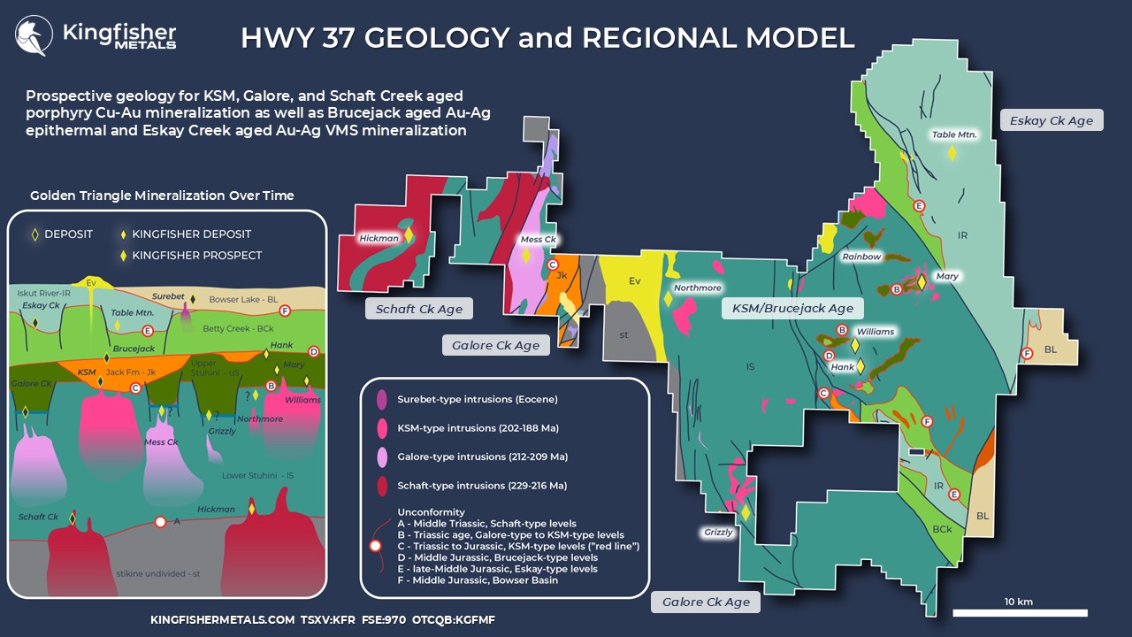
The broad grassroots Northmore target area is host to Texas Creek, or KSM-type, intrusions as well as syenite interpreted by previous workers to be Galore Creek intrusions. The Company plans to undertake further work to determine whether a KSM or Galore-style exploration model will apply here.
Initial work to further refine targets at Northmore will include expanding soil coverage to capture the full extent of anomalism and new geophysical studies. This new data coupled with 3D inversions of historical geophysical datasets will provide insight into the plumbing system and porphyry target areas for additional IP surveys and drill target generation within the large soil anomaly.
Gallery
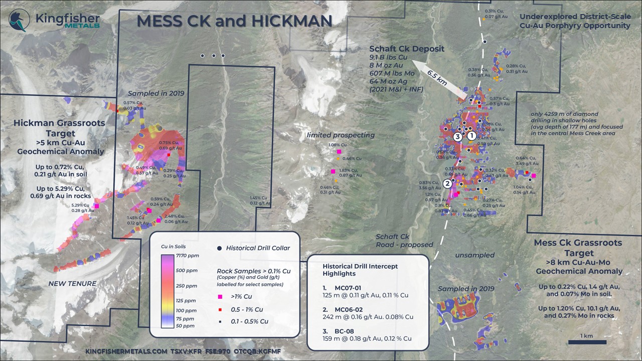
The Mess Creek soil and rock anomaly (Minfile 104G 260) extends a minimum of 8 km along the a north south trend with elevated Au-Cu-Mo. In areas, the width of the anomaly measures a minimum of 2 km but sampling along the trend is not sufficient to characterize either the full strike length or width of the anomaly.
A total of 24 holes to average depth of 177 m are focused in a 2.3 km N-S by 1 km E-W drill footprint. The drill area intersected anomalous Cu-Au including: 125 m of 0.11 g/t Au and 0.11% Cu (MC07-01), 242 m of 0.16 g/t Au and 0.08% Cu (MC06-02), and 159 m of 0.18 g/t Au and 0.12% Cu (BC-08).
Geophysical coverage at Mess Creek includes 447 line- km of a modern high resolution aeromagnetic survey that encompasses the Mess Creek soil anomaly. The principal Mess Creek soil anomaly is covered by 1970’s era induced-polarization-resistivity data currently in paper format with limited depth penetration. The Company intends to digitize paper format data and to generate inversion products for both IP and magnetic data for 3D visualization and structural interpretation.
The Mess Creek area coincides with a trend of Galore Creek intrusions (the Loon Lake stock) and historical work areas document Galore-like alkalic Cu-Au-bearing syenite porphyry intrusions. The Mess Creek target area is also highly prospective for intrusion-related gold systems (e.g., Brucejack or Snip) based on the presence of the regional scale Mess Creek fault system.
The Company intends to completely capture the anomaly through expanded soil sample surveys and follow-up with geophysical surveys. These results coupled with 3D visualization techniques to historical geophysical and drill results will inform drill targeting work.
HoleID | From (m) | To (m) | Interval (m) | Au g/t | Cu % | Ag g/t |
MC06-01 | 1.5 | 60.1 | 58.5 | 0.21 | 0.08 | 0.64 |
MC06-02 | 64.0 | 253.1 | 189.1 | 0.15 | 0.08 | 1.46 |
MC06-04 | 54.1 | 147.7 | 93.6 | 0.12 | 0.06 | 0.51 |
MC07-01 | 39.9 | 167.9 | 128.0 | 0.11 | 0.11 | 0.57 |
MC07-03 | 78.8 | 123.1 | 44.3 | 0.08 | 0.27 | 4.28 |
BC-08 | 9 | 183 | 174 | 0.17 | 0.11 | 1.25 |
Mess Creek Drill Highlights
Gallery


The Hickman grassroots target area (Minfile 104G 470) is an open and relatively new 3.5 km-long Cu-Au-Mo soil anomaly that was delineated in 2019 without follow-up (Figure 3). Surface work identified the presence of potassic-altered porphyry stockwork on surface and rock sampled up to 0.69 g/t Au and 2.5% Cu.
The sampled region reflects a comparable geological setting to the Schaft Creek deposit, located ~7 km north of the target. Both the Schaft Creek deposit* and Hickman target lie at the margin of the Late Triassic Hickman batholith (225 to 222 Ma) associated with monzodiorite porphyry phases.
No ground geophysical surveys have been completed at Hickman.

*The Company notes that mineralization on nearby projects is not indicative of mineralization on the HWY 37 Project
Gallery
HWY 37 is host to two large regions of Eskay-type stratigraphy in the Eskay rift with potential to host a new precious metal-rich VMS district similar to Eskay Creek. The Eskay Creek historical mine produced 3.3 M oz Au and 160 M oz Ag at 45 g/t Au and 2224 g/t Ag*. Limited historical exploration by Noranda at Table Mountain in the 1990s on the NE HWY 37 Project was carried out despite stream sediment anomalies up to 207 ppb Au. Rock sampling has returned encouraging grades up to 4.7 g/t Au, 22.4 g/t Ag, 1.56% Cu, 1.8% Pb, and 1.7% Sb. Soil sampling coverage is restricted to a small area that is highly anomalous in zinc.
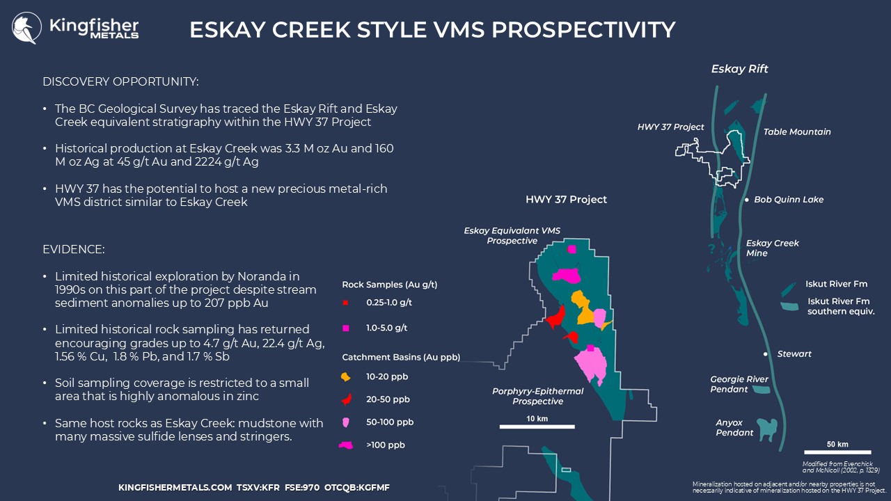
*The Company notes that mineralization on nearby projects is not indicative of mineralization on the HWY 37 Project.
Gallery